El Papayo geodata
El Papayo (Guerrero) is a populated place; located in Mexico in America/Mexico_City (GMT-6) time zone. With population of 2,247 people, there are 3913 cities with bigger population in this country. Compared to other cities in Mexico, 88.4% of cities are located further ↑North; 66.9% of cities are located further →East and 90.4% of cities have higher elevation than El Papayo. Note1


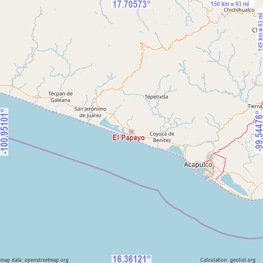
El Papayo GPS coordinates[2]
17° 2' 4.848" North, 100° 14' 52.368" West
| Map corner | latitude | longitude |
|---|---|---|
| Upper-left | 17.70573°, | -100.95101° |
| Center: | 17.03468°, | -100.24788° |
| Lower-right: | 16.36121°, | -99.54476° |
| Map W x H: | 149.5×149.5 km | = 92.9×92.9mi |
| max Lat: | 32.7° ⇑88.4% North |
| El Papayo: | 17.03468° |
| min Lat: | ⇓11.6% South 14.53588° |
| min Long | El Papayo | max Long |
| -117.105° | -100.24788° | -86.73105° |
| W 33.1%⇐ | ⇒66.9% E |
Elevation
Elevation of El Papayo is 23 m = 75 ft, and this is 1230.7 m = 4038 ft below average elevation for this country.
| Max E: |
3497 m = 11473 ft | 90.4% |
| Avg. | 1253.7 m = 4113 ft | |
| El Papayo | 23 m = 75 ft | |
Min E: |
-1 m = -3 ft | 9.6% |
See also: Mexico elevation on elevation.city.
Geographical zone
El Papayo is located in North Torrid zone (between Equator and Tropic of Cancer). Distance of this Northern Tropic circle is 711.8 km =442.3 mi to North.| Distance of | km | miles | from El Papayo |
|---|---|---|---|
| North Pole | 8113 | 5041.2 | to North |
| Arctic Circle | 5507.1 | 3422 | to North |
| Tropic Cancer | 711.8 | 442.3 | to North |
| Equator | 1894.1 | 1176.9 | to South |


Nearby cities:
15 places around El Papayo: (largest is in red/bold)
• Cacalutla
14.8 km =9.2 mi,  312°
312°
• Carrera Larga
15.8 km =9.8 mi,  86°
86°
• Cayaco
2.6 km =1.6 mi,  302°
302°
• Colonia Cuauhtémoc
12.1 km =7.5 mi, 309°
• Colonia Lázaro Cárdenas
17.3 km =10.7 mi,  104°
104°
• Coyuca de Benítez
17.3 km =10.7 mi, 99°
• El Bejuco
16.8 km =10.4 mi,  113°
113°
• El Espinalillo
14 km =8.7 mi, 113°
• El Zapote
6.5 km =4 mi,  118°
118°
• La Barra
17.7 km =11 mi, 122°
• Las Lomas
17.3 km =10.7 mi, 109°
• Playa del Carrizal
13.8 km =8.6 mi,  125°
125°
• Pénjamo
14.3 km =8.9 mi, 98°
• San Nicolás
14.3 km =8.9 mi, 116°
• Zacualpan
10.3 km =6.4 mi, 306°
Sources, notices
• [Note1] Compared only with cities in Mexico existing in our database
• [Src1] Map data: © OpenStreetMap contributors (CC-BY-SA)
• [Src2] Other city data from geonames.org with taken over terms of usage.
• [Src3] Geographical zone / Annual Mean Temperature by Robert A. Rohde @ Wikipedia
