Cayaco geodata
Cayaco (Guerrero) is a populated place; located in Mexico in America/Mexico_City (GMT-6) time zone. With population of 1,242 people, there are 6984 cities with bigger population in this country. Compared to other cities in Mexico, 88.2% of cities are located further ↑North; 67.1% of cities are located further →East and 93.5% of cities have higher elevation than Cayaco. Note1


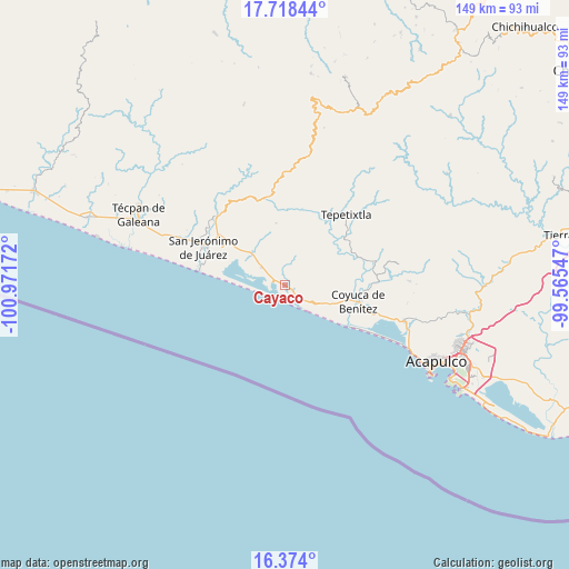
Cayaco GPS coordinates[2]
17° 2' 50.748" North, 100° 16' 6.924" West
| Map corner | latitude | longitude |
|---|---|---|
| Upper-left | 17.71844°, | -100.97172° |
| Center: | 17.04743°, | -100.26859° |
| Lower-right: | 16.374°, | -99.56547° |
| Map W x H: | 149.5×149.5 km | = 92.9×92.9mi |
| max Lat: | 32.7° ⇑88.2% North |
| Cayaco: | 17.04743° |
| min Lat: | ⇓11.8% South 14.53588° |
| min Long | Cayaco | max Long |
| -117.105° | -100.26859° | -86.73105° |
| W 32.9%⇐ | ⇒67.1% E |
Elevation
Elevation of Cayaco is 16 m = 52 ft, and this is 1237.7 m = 4061 ft below average elevation for this country.
| Max E: |
3497 m = 11473 ft | 93.5% |
| Avg. | 1253.7 m = 4113 ft | |
| Cayaco | 16 m = 52 ft | |
Min E: |
-1 m = -3 ft | 6.5% |
See also: Mexico elevation on elevation.city.
Geographical zone
Cayaco is located in North Torrid zone (between Equator and Tropic of Cancer). Distance of this Northern Tropic circle is 710.4 km =441.4 mi to North.| Distance of | km | miles | from Cayaco |
|---|---|---|---|
| North Pole | 8111.6 | 5040.3 | to North |
| Arctic Circle | 5505.7 | 3421.1 | to North |
| Tropic Cancer | 710.4 | 441.4 | to North |
| Equator | 1895.5 | 1177.8 | to South |


Nearby cities:
15 places around Cayaco: (largest is in red/bold)
• Alcholoa
18.8 km =11.7 mi,  307°
307°
• Cacalutla
12.2 km =7.6 mi, 314°
• Carrera Larga
18 km =11.2 mi,  91°
91°
• Colonia Buenos Aires
19.7 km =12.2 mi, 308°
• Colonia Cuauhtémoc
9.5 km =5.9 mi, 311°
• Coyuca de Benítez
19.8 km =12.3 mi,  102°
102°
• El Bejuco
19.4 km =12.1 mi,  114°
114°
• El Espinalillo
16.6 km =10.3 mi, 114°
• El Papayo
2.6 km =1.6 mi,  122°
122°
• El Quemado
16.4 km =10.2 mi,  352°
352°
• El Zapote
9.1 km =5.7 mi, 119°
• Playa del Carrizal
16.4 km =10.2 mi,  125°
125°
• Pénjamo
16.8 km =10.4 mi, 102°
• San Nicolás
16.9 km =10.5 mi, 117°
• Zacualpan
7.6 km =4.7 mi, 307°
Sources, notices
• [Note1] Compared only with cities in Mexico existing in our database
• [Src1] Map data: © OpenStreetMap contributors (CC-BY-SA)
• [Src2] Other city data from geonames.org with taken over terms of usage.
• [Src3] Geographical zone / Annual Mean Temperature by Robert A. Rohde @ Wikipedia
