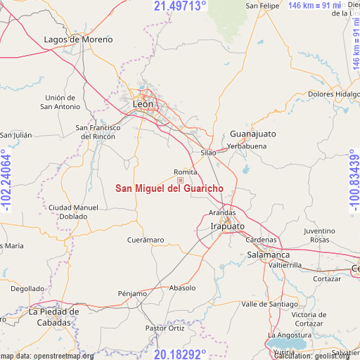
San Miguel del Guaricho geodata
San Miguel del Guaricho (Guanajuato) is a populated place; located in Mexico in America/Mexico_City (GMT-6) time zone. With population of 762 people, there are 11496 cities with bigger population in this country. Compared to other cities in Mexico, 73.9% of cities are located further ↓South; 77.7% of cities are located further →East and 60.9% of cities have lower elevation than San Miguel del Guaricho. Note1
Current local time in San Miguel del Guaricho:
08:05 AM, WednesdayDifference from your time zone: hours


San Miguel del Guaricho GPS coordinates[2]
20° 50' 29.256" North, 101° 32' 15.036" West
| Map corner | latitude | longitude |
|---|---|---|
| Upper-left | 21.49713°, | -102.24064° |
| Center: | 20.84146°, | -101.53751° |
| Lower-right: | 20.18292°, | -100.83439° |
| Map W x H: | 146.1×146.1 km | = 90.8×90.8mi |
| max Lat: | 32.7° ⇑26.1% North |
| San Miguel del Guaricho: | 20.84146° |
| min Lat: | ⇓73.9% South 14.53588° |
| min Long | San Miguel del | max Long |
| -117.105° | -101.53751° | -86.73105° |
| W 22.3%⇐ | ⇒77.7% E |
Elevation
Elevation of San Miguel del Guaricho is 1742 m = 5715 ft, and this is 488.3 m = 1602 ft above average elevation for this country.
| Max E: |
3497 m = 11473 ft | 39.1% |
| San Miguel del Guaricho | 1742 m 5715 ft | |
| Avg. | 1253.7 m = 4113 ft | |
Min E: |
-1 m = -3 ft | 60.9% |
See also: Mexico elevation on elevation.city.
Geographical zone
San Miguel del Guaricho is located in North Torrid zone (between Equator and Tropic of Cancer). Distance of this Northern Tropic circle is 288.6 km =179.3 mi to North.| Distance of | km | miles | from San Miguel del Guaricho |
|---|---|---|---|
| North Pole | 7689.7 | 4778.2 | to North |
| Arctic Circle | 5083.8 | 3158.9 | to North |
| Tropic Cancer | 288.6 | 179.3 | to North |
| Equator | 2317.4 | 1440 | to South |


Nearby cities:
15 places around San Miguel del Guaricho: (largest is in red/bold)
• Colonia Rafael Corrales Ayala
7.1 km =4.4 mi,  18°
18°
• Cruz de Aguilar
6.6 km =4.1 mi,  243°
243°
• El Carmen de Sánchez
6.5 km =4 mi,  207°
207°
• El Escoplo
8.1 km =5 mi, 19°
• El Mármol
4.3 km =2.7 mi,  275°
275°
• Las Liebres
7 km =4.3 mi,  95°
95°
• Lourdes
6.5 km =4 mi,  295°
295°
• Maravillas de las Victorias
7.1 km =4.4 mi,  79°
79°
• Mezquite Gordo
5.5 km =3.4 mi,  122°
122°
• Romita
4 km =2.5 mi,  32°
32°
• San Clemente
3.3 km =2.1 mi,  185°
185°
• San Francisco Puerta Grande
6.8 km =4.2 mi,  55°
55°
• San Gonzalo
6.2 km =3.9 mi,  325°
325°
• Santa Rosa de Rivas
6.7 km =4.2 mi,  178°
178°
• Silva
6.2 km =3.9 mi,  347°
347°
Sources, notices
• [Note1] Compared only with cities in Mexico existing in our database
• [Src1] Map data: © OpenStreetMap contributors (CC-BY-SA)
• [Src2] Other city data from geonames.org with taken over terms of usage.
• [Src3] Geographical zone / Annual Mean Temperature by Robert A. Rohde @ Wikipedia
