Estribo geodata
Estribo (San Luis Potosí) is a populated place; located in Mexico in America/Mexico_City (GMT-6) time zone. With population of 533 people, there are 15888 cities with bigger population in this country. Compared to other cities in Mexico, 88.2% of cities are located further ↓South; 77.9% of cities are located further →East and 74.6% of cities have lower elevation than Estribo. Note1


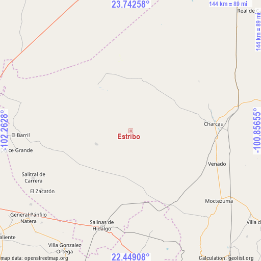
Estribo GPS coordinates[2]
23° 5' 50.604" North, 101° 33' 34.812" West
| Map corner | latitude | longitude |
|---|---|---|
| Upper-left | 23.74258°, | -102.2628° |
| Center: | 23.09739°, | -101.55967° |
| Lower-right: | 22.44908°, | -100.85655° |
| Map W x H: | 143.8×143.8 km | = 89.4×89.4mi |
| max Lat: | 32.7° ⇑11.8% North |
| Estribo: | 23.09739° |
| min Lat: | ⇓88.2% South 14.53588° |
| min Long | Estribo | max Long |
| -117.105° | -101.55967° | -86.73105° |
| W 22.1%⇐ | ⇒77.9% E |
Elevation
Elevation of Estribo is 2023 m = 6637 ft, and this is 769.3 m = 2524 ft above average elevation for this country.
| Max E: |
3497 m = 11473 ft | 25.4% |
| Estribo | 2023 m 6637 ft | |
| Avg. | 1253.7 m = 4113 ft | |
Min E: |
-1 m = -3 ft | 74.6% |
See also: Mexico elevation on elevation.city.
Geographical zone
Estribo is located in North Torrid zone (between Equator and Tropic of Cancer). Distance of this Northern Tropic circle is 37.7 km =23.4 mi to North.| Distance of | km | miles | from Estribo |
|---|---|---|---|
| North Pole | 7438.9 | 4622.3 | to North |
| Arctic Circle | 4833 | 3003.1 | to North |
| Tropic Cancer | 37.7 | 23.4 | to North |
| Equator | 2568.2 | 1595.8 | to South |


Nearby cities:
15 places around Estribo: (largest is in red/bold)
• Cañada Verde
46.7 km =29 mi,  92°
92°
• Charcas
45.8 km =28.5 mi, 85°
• Hernández
49.4 km =30.7 mi,  261°
261°
• La Dulcita
49.1 km =30.5 mi,  240°
240°
• La Herradura
20.5 km =12.7 mi,  247°
247°
• Palma Pegada
49.2 km =30.6 mi,  208°
208°
• Polocote de Arriba
46.5 km =28.9 mi,  109°
109°
• Providencia
46.7 km =29 mi,  279°
279°
• Punteros
44.9 km =27.9 mi, 210°
• Reforma
38.9 km =24.2 mi,  193°
193°
• San Francisco
39.5 km =24.5 mi, 254°
• Santa Lucía
50.6 km =31.4 mi,  226°
226°
• Santa Matilde
38.2 km =23.7 mi,  312°
312°
• Santo Domingo
31.2 km =19.4 mi,  324°
324°
• Villa de Ramos
46.6 km =29 mi, 230°
Sources, notices
• [Note1] Compared only with cities in Mexico existing in our database
• [Src1] Map data: © OpenStreetMap contributors (CC-BY-SA)
• [Src2] Other city data from geonames.org with taken over terms of usage.
• [Src3] Geographical zone / Annual Mean Temperature by Robert A. Rohde @ Wikipedia
