Providencia geodata
Providencia (San Luis Potosí) is a populated place; located in Mexico in America/Mexico_City (GMT-6) time zone. With population of 817 people, there are 10690 cities with bigger population in this country. Compared to other cities in Mexico, 88.3% of cities are located further ↓South; 81% of cities are located further →East and 75.9% of cities have lower elevation than Providencia. Note1


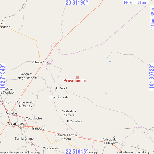
Providencia GPS coordinates[2]
23° 10' 1.668" North, 102° 0' 37.26" West
| Map corner | latitude | longitude |
|---|---|---|
| Upper-left | 23.81198°, | -102.71348° |
| Center: | 23.16713°, | -102.01035° |
| Lower-right: | 22.51915°, | -101.30723° |
| Map W x H: | 143.7×143.8 km | = 89.3×89.4mi |
| max Lat: | 32.7° ⇑11.7% North |
| Providencia: | 23.16713° |
| min Lat: | ⇓88.3% South 14.53588° |
| min Long | Providencia | max Long |
| -117.105° | -102.01035° | -86.73105° |
| W 19%⇐ | ⇒81% E |
Elevation
Elevation of Providencia is 2047 m = 6716 ft, and this is 793.3 m = 2603 ft above average elevation for this country.
| Max E: |
3497 m = 11473 ft | 24.1% |
| Providencia | 2047 m 6716 ft | |
| Avg. | 1253.7 m = 4113 ft | |
Min E: |
-1 m = -3 ft | 75.9% |
See also: Mexico elevation on elevation.city.
Geographical zone
Providencia is located in North Torrid zone (between Equator and Tropic of Cancer). Distance of this Northern Tropic circle is 30 km =18.6 mi to North.| Distance of | km | miles | from Providencia |
|---|---|---|---|
| North Pole | 7431.1 | 4617.5 | to North |
| Arctic Circle | 4825.2 | 2998.2 | to North |
| Tropic Cancer | 30 | 18.6 | to North |
| Equator | 2575.9 | 1600.6 | to South |


Nearby cities:
15 places around Providencia: (largest is in red/bold)
• Cervantes
25 km =15.5 mi,  359°
359°
• Chaparrosa
28.8 km =17.9 mi,  251°
251°
• Chupaderos
32.2 km =20 mi,  268°
268°
• Dulce Grande
24.9 km =15.5 mi,  222°
222°
• El Barril
17.9 km =11.1 mi,  235°
235°
• El Rucio
27.7 km =17.2 mi,  344°
344°
• Hernández
15.1 km =9.4 mi,  190°
190°
• Illescas
16 km =9.9 mi,  300°
300°
• Jesús María
18.7 km =11.6 mi, 265°
• La Herradura
31.2 km =19.4 mi,  119°
119°
• La Prieta
25.9 km =16.1 mi,  329°
329°
• Los Zacatones
23.3 km =14.5 mi, 191°
• San Francisco
20.2 km =12.6 mi,  156°
156°
• Santa Matilde
25.5 km =15.8 mi,  44°
44°
• Zancarron
31.3 km =19.4 mi,  316°
316°
Sources, notices
• [Note1] Compared only with cities in Mexico existing in our database
• [Src1] Map data: © OpenStreetMap contributors (CC-BY-SA)
• [Src2] Other city data from geonames.org with taken over terms of usage.
• [Src3] Geographical zone / Annual Mean Temperature by Robert A. Rohde @ Wikipedia
