La Popular geodata
La Popular (Durango) is a populated place; located in Mexico in America/Monterrey (GMT-6) time zone. With population of 3,406 people, there are 2670 cities with bigger population in this country. Compared to other cities in Mexico, 93.5% of cities are located further ↓South; 88.2% of cities are located further →East and 57.3% of cities have higher elevation than La Popular. Note1


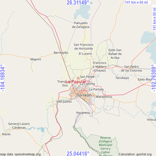
La Popular GPS coordinates[2]
25° 40' 46.236" North, 103° 27' 58.356" West
| Map corner | latitude | longitude |
|---|---|---|
| Upper-left | 26.31149°, | -104.16934° |
| Center: | 25.67951°, | -103.46621° |
| Lower-right: | 25.04416°, | -102.76309° |
| Map W x H: | 140.9×140.9 km | = 87.6×87.6mi |
| max Lat: | 32.7° ⇑6.5% North |
| La Popular: | 25.67951° |
| min Lat: | ⇓93.5% South 14.53588° |
| min Long | La Popular | max Long |
| -117.105° | -103.46621° | -86.73105° |
| W 11.8%⇐ | ⇒88.2% E |
Elevation
Elevation of La Popular is 1117 m = 3665 ft, and this is 136.7 m = 448 ft below average elevation for this country.
| Max E: |
3497 m = 11473 ft | 57.3% |
| Avg. | 1253.7 m = 4113 ft | |
| La Popular | 1117 m = 3665 ft | |
Min E: |
-1 m = -3 ft | 42.7% |
See also: Mexico elevation on elevation.city.
Geographical zone
La Popular is located in North temperate zone (between Tropic of Cancer and the Arctic Circle). Distance of this Northern Tropic circle is 249.4 km =155 mi to South.| Distance of | km | miles | from La Popular |
|---|---|---|---|
| North Pole | 7151.8 | 4443.9 | to North |
| Arctic Circle | 4545.9 | 2824.7 | to North |
| Tropic Cancer | 249.4 | 155 | to South |
| Equator | 2855.3 | 1774.2 | to South |


Nearby cities:
15 places around La Popular: (largest is in red/bold)
• Bucareli
7.1 km =4.4 mi,  255°
255°
• El Cariño
5.8 km =3.6 mi,  155°
155°
• El Castillo
4.4 km =2.7 mi,  110°
110°
• El Vergel
7.1 km =4.4 mi,  231°
231°
• El Vergelito
5.1 km =3.2 mi,  33°
33°
• Esmeralda
7.9 km =4.9 mi, 26°
• Estación Viñedo
5.7 km =3.5 mi, 109°
• La Competencia
6.2 km =3.9 mi, 262°
• La Tehua
5.4 km =3.4 mi,  47°
47°
• Manila
7.5 km =4.7 mi,  279°
279°
• Nazas (Las Lagartijas)
5.5 km =3.4 mi,  172°
172°
• Palo Blanco
7.1 km =4.4 mi,  307°
307°
• Pastor Rovaix
4.4 km =2.7 mi,  274°
274°
• San Felipe
8.5 km =5.3 mi,  80°
80°
• San José de Viñedo
7.2 km =4.5 mi,  118°
118°
Sources, notices
• [Note1] Compared only with cities in Mexico existing in our database
• [Src1] Map data: © OpenStreetMap contributors (CC-BY-SA)
• [Src2] Other city data from geonames.org with taken over terms of usage.
• [Src3] Geographical zone / Annual Mean Temperature by Robert A. Rohde @ Wikipedia
