Dolores geodata
Dolores (Durango) is a populated place; located in Mexico in America/Monterrey (GMT-6) time zone. With population of 659 people, there are 13168 cities with bigger population in this country. Compared to other cities in Mexico, 93.8% of cities are located further ↓South; 88.6% of cities are located further →East and 57.3% of cities have higher elevation than Dolores. Note1


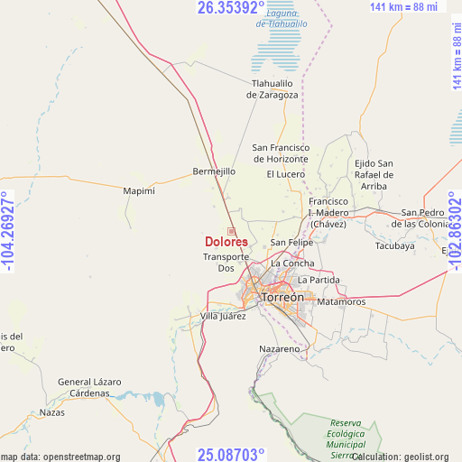
Dolores GPS coordinates[2]
25° 43' 19.776" North, 103° 33' 58.104" West
| Map corner | latitude | longitude |
|---|---|---|
| Upper-left | 26.35392°, | -104.26927° |
| Center: | 25.72216°, | -103.56614° |
| Lower-right: | 25.08703°, | -102.86302° |
| Map W x H: | 140.9×140.9 km | = 87.6×87.6mi |
| max Lat: | 32.7° ⇑6.2% North |
| Dolores: | 25.72216° |
| min Lat: | ⇓93.8% South 14.53588° |
| min Long | Dolores | max Long |
| -117.105° | -103.56614° | -86.73105° |
| W 11.4%⇐ | ⇒88.6% E |
Elevation
Elevation of Dolores is 1116 m = 3661 ft, and this is 137.7 m = 452 ft below average elevation for this country.
| Max E: |
3497 m = 11473 ft | 57.3% |
| Avg. | 1253.7 m = 4113 ft | |
| Dolores | 1116 m = 3661 ft | |
Min E: |
-1 m = -3 ft | 42.7% |
See also: Mexico elevation on elevation.city.
Geographical zone
Dolores is located in North temperate zone (between Tropic of Cancer and the Arctic Circle). Distance of this Northern Tropic circle is 254.1 km =157.9 mi to South.| Distance of | km | miles | from Dolores |
|---|---|---|---|
| North Pole | 7147 | 4440.9 | to North |
| Arctic Circle | 4541.1 | 2821.7 | to North |
| Tropic Cancer | 254.1 | 157.9 | to South |
| Equator | 2860 | 1777.1 | to South |


Nearby cities:
15 places around Dolores: (largest is in red/bold)
• Brittingham
4 km =2.5 mi,  355°
355°
• Bucareli
7.2 km =4.5 mi,  154°
154°
• Dinamita
9.3 km =5.8 mi,  270°
270°
• El Vergel
10.2 km =6.3 mi, 153°
• Estación Noé
1.1 km =0.7 mi,  113°
113°
• La Aurora
3.6 km =2.2 mi,  311°
311°
• La Competencia
6.8 km =4.2 mi, 145°
• La Luz
5.4 km =3.4 mi,  40°
40°
• Manila
4.4 km =2.7 mi,  142°
142°
• Marta
9.3 km =5.8 mi,  324°
324°
• Palo Blanco
4.4 km =2.7 mi,  95°
95°
• Pastor Rovaix
7.1 km =4.4 mi,  128°
128°
• Santa Clara
10 km =6.2 mi,  343°
343°
• Seis de Octubre
10.2 km =6.3 mi, 355°
• Transporte
10.1 km =6.3 mi,  165°
165°
Sources, notices
• [Note1] Compared only with cities in Mexico existing in our database
• [Src1] Map data: © OpenStreetMap contributors (CC-BY-SA)
• [Src2] Other city data from geonames.org with taken over terms of usage.
• [Src3] Geographical zone / Annual Mean Temperature by Robert A. Rohde @ Wikipedia
