Transporte geodata
Transporte (Durango) is a populated place; located in Mexico in America/Monterrey (GMT-6) time zone. With population of 2,624 people, there are 3376 cities with bigger population in this country. Compared to other cities in Mexico, 93.2% of cities are located further ↓South; 88.5% of cities are located further →East and 56.9% of cities have higher elevation than Transporte. Note1


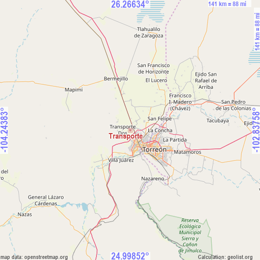
Transporte GPS coordinates[2]
25° 38' 2.796" North, 103° 32' 26.52" West
| Map corner | latitude | longitude |
|---|---|---|
| Upper-left | 26.26634°, | -104.24383° |
| Center: | 25.63411°, | -103.5407° |
| Lower-right: | 24.99852°, | -102.83758° |
| Map W x H: | 141×141 km | = 87.6×87.6mi |
| max Lat: | 32.7° ⇑6.8% North |
| Transporte: | 25.63411° |
| min Lat: | ⇓93.2% South 14.53588° |
| min Long | Transporte | max Long |
| -117.105° | -103.5407° | -86.73105° |
| W 11.5%⇐ | ⇒88.5% E |
Elevation
Elevation of Transporte is 1124 m = 3688 ft, and this is 129.7 m = 426 ft below average elevation for this country.
| Max E: |
3497 m = 11473 ft | 56.9% |
| Avg. | 1253.7 m = 4113 ft | |
| Transporte | 1124 m = 3688 ft | |
Min E: |
-1 m = -3 ft | 43.1% |
See also: Mexico elevation on elevation.city.
Geographical zone
Transporte is located in North temperate zone (between Tropic of Cancer and the Arctic Circle). Distance of this Northern Tropic circle is 244.3 km =151.8 mi to South.| Distance of | km | miles | from Transporte |
|---|---|---|---|
| North Pole | 7156.8 | 4447 | to North |
| Arctic Circle | 4550.9 | 2827.8 | to North |
| Tropic Cancer | 244.3 | 151.8 | to South |
| Equator | 2850.2 | 1771 | to South |


Nearby cities:
15 places around Transporte: (largest is in red/bold)
• Bucareli
3.3 km =2.1 mi,  9°
9°
• Ciudad Lerdo
10.9 km =6.8 mi,  171°
171°
• Dolores
10.1 km =6.3 mi,  345°
345°
• Dolores (La Borrega)
4.7 km =2.9 mi,  190°
190°
• El Cariño
9.8 km =6.1 mi,  91°
91°
• El Vergel
2 km =1.2 mi,  72°
72°
• Estación Noé
9.5 km =5.9 mi, 350°
• Gómez Palacio
8.4 km =5.2 mi,  147°
147°
• La Competencia
4.4 km =2.7 mi,  17°
17°
• La Luz
7 km =4.3 mi,  270°
270°
• La Popular
9 km =5.6 mi,  55°
55°
• Manila
6.3 km =3.9 mi,  0°
0°
• Nazas (Las Lagartijas)
8.2 km =5.1 mi, 92°
• Palo Blanco
9.5 km =5.9 mi, 11°
• Pastor Rovaix
6.2 km =3.9 mi,  29°
29°
Sources, notices
• [Note1] Compared only with cities in Mexico existing in our database
• [Src1] Map data: © OpenStreetMap contributors (CC-BY-SA)
• [Src2] Other city data from geonames.org with taken over terms of usage.
• [Src3] Geographical zone / Annual Mean Temperature by Robert A. Rohde @ Wikipedia
