Manila geodata
Manila (Durango) is a populated place; located in Mexico in America/Monterrey (GMT-6) time zone. With population of 547 people, there are 15556 cities with bigger population in this country. Compared to other cities in Mexico, 93.6% of cities are located further ↓South; 88.5% of cities are located further →East and 57.2% of cities have higher elevation than Manila. Note1


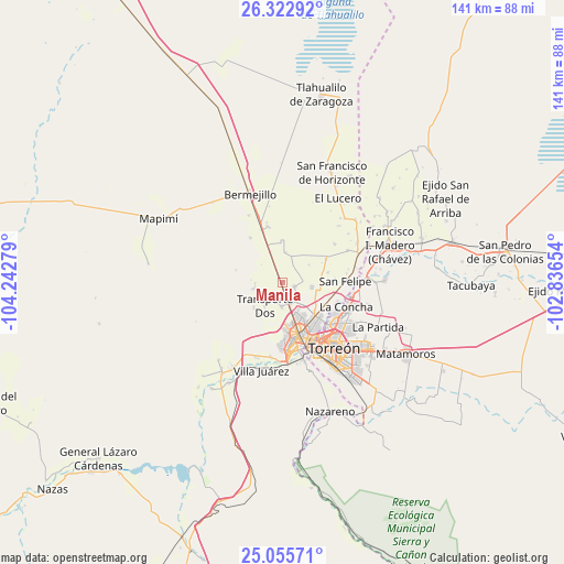
Manila GPS coordinates[2]
25° 41' 27.6" North, 103° 32' 22.776" West
| Map corner | latitude | longitude |
|---|---|---|
| Upper-left | 26.32292°, | -104.24279° |
| Center: | 25.691°, | -103.53966° |
| Lower-right: | 25.05571°, | -102.83654° |
| Map W x H: | 140.9×140.9 km | = 87.6×87.6mi |
| max Lat: | 32.7° ⇑6.4% North |
| Manila: | 25.691° |
| min Lat: | ⇓93.6% South 14.53588° |
| min Long | Manila | max Long |
| -117.105° | -103.53966° | -86.73105° |
| W 11.5%⇐ | ⇒88.5% E |
Elevation
Elevation of Manila is 1118 m = 3668 ft, and this is 135.7 m = 445 ft below average elevation for this country.
| Max E: |
3497 m = 11473 ft | 57.2% |
| Avg. | 1253.7 m = 4113 ft | |
| Manila | 1118 m = 3668 ft | |
Min E: |
-1 m = -3 ft | 42.8% |
See also: Mexico elevation on elevation.city.
Geographical zone
Manila is located in North temperate zone (between Tropic of Cancer and the Arctic Circle). Distance of this Northern Tropic circle is 250.7 km =155.8 mi to South.| Distance of | km | miles | from Manila |
|---|---|---|---|
| North Pole | 7150.5 | 4443.1 | to North |
| Arctic Circle | 4544.6 | 2823.9 | to North |
| Tropic Cancer | 250.7 | 155.8 | to South |
| Equator | 2856.6 | 1775 | to South |


Nearby cities:
15 places around Manila: (largest is in red/bold)
• Brittingham
8 km =5 mi,  338°
338°
• Bucareli
3.1 km =1.9 mi,  171°
171°
• Dolores
4.4 km =2.7 mi,  322°
322°
• El Vergel
6 km =3.7 mi,  162°
162°
• El Vergelito
10.6 km =6.6 mi,  73°
73°
• Estación Noé
3.4 km =2.1 mi,  331°
331°
• La Aurora
7.9 km =4.9 mi, 317°
• La Competencia
2.4 km =1.5 mi,  151°
151°
• La Luz
7.6 km =4.7 mi,  6°
6°
• La Luz
9.5 km =5.9 mi,  228°
228°
• La Popular
7.5 km =4.7 mi,  99°
99°
• Nazas (Las Lagartijas)
10.5 km =6.5 mi,  129°
129°
• Palo Blanco
3.5 km =2.2 mi,  30°
30°
• Pastor Rovaix
3.1 km =1.9 mi,  108°
108°
• Transporte
6.3 km =3.9 mi,  180°
180°
Sources, notices
• [Note1] Compared only with cities in Mexico existing in our database
• [Src1] Map data: © OpenStreetMap contributors (CC-BY-SA)
• [Src2] Other city data from geonames.org with taken over terms of usage.
• [Src3] Geographical zone / Annual Mean Temperature by Robert A. Rohde @ Wikipedia
