Culiacancito geodata
Culiacancito (Sinaloa) is a populated place; located in Mexico in America/Mazatlan (GMT-7) time zone. With population of 4,309 people, there are 2129 cities with bigger population in this country. Compared to other cities in Mexico, 91.6% of cities are located further ↓South; 95% of cities are located further →East and 87.2% of cities have higher elevation than Culiacancito. Note1


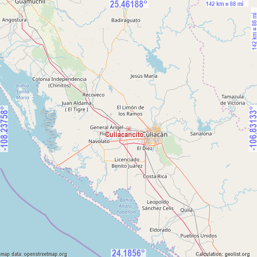
Culiacancito GPS coordinates[2]
24° 49' 31.368" North, 107° 32' 4.02" West
| Map corner | latitude | longitude |
|---|---|---|
| Upper-left | 25.46188°, | -108.23758° |
| Center: | 24.82538°, | -107.53445° |
| Lower-right: | 24.1856°, | -106.83133° |
| Map W x H: | 141.9×141.9 km | = 88.2×88.2mi |
| max Lat: | 32.7° ⇑8.4% North |
| Culiacancito: | 24.82538° |
| min Lat: | ⇓91.6% South 14.53588° |
| min Long | Culiacancito | max Long |
| -117.105° | -107.53445° | -86.73105° |
| W 5%⇐ | ⇒95% E |
Elevation
Elevation of Culiacancito is 33 m = 108 ft, and this is 1220.7 m = 4005 ft below average elevation for this country.
| Max E: |
3497 m = 11473 ft | 87.2% |
| Avg. | 1253.7 m = 4113 ft | |
| Culiacancito | 33 m = 108 ft | |
Min E: |
-1 m = -3 ft | 12.8% |
See also: Mexico elevation on elevation.city.
Geographical zone
Culiacancito is located in North temperate zone (between Tropic of Cancer and the Arctic Circle). Distance of this Northern Tropic circle is 154.4 km =95.9 mi to South.| Distance of | km | miles | from Culiacancito |
|---|---|---|---|
| North Pole | 7246.7 | 4502.9 | to North |
| Arctic Circle | 4640.9 | 2883.7 | to North |
| Tropic Cancer | 154.4 | 95.9 | to South |
| Equator | 2760.3 | 1715.2 | to South |


Nearby cities:
15 places around Culiacancito: (largest is in red/bold)
• Bacurimí
8.4 km =5.2 mi,  100°
100°
• Batallón
8.8 km =5.5 mi,  219°
219°
• Bellavista
7.4 km =4.6 mi, 100°
• Campo Balbuena
8.9 km =5.5 mi,  190°
190°
• Campo Lo de Beltrán
8 km =5 mi,  262°
262°
• Cofradía de San Pedro
7.5 km =4.7 mi,  245°
245°
• Ejido Convención de Aguascalientes
12.4 km =7.7 mi,  233°
233°
• Ejido la Paloma
12.3 km =7.6 mi,  278°
278°
• El Limón de los Ramos
9.9 km =6.2 mi,  6°
6°
• Estación Rosales
4.8 km =3 mi,  285°
285°
• General Ángel Flores (La Palma)
12.4 km =7.7 mi,  266°
266°
• La Bebelama de San Pedro
5.3 km =3.3 mi, 227°
• La Sinaloa
11.1 km =6.9 mi, 233°
• Lo de Sauceda
8.8 km =5.5 mi, 250°
• Los Arredondo (Los Arredondo de San Pedro)
7.3 km =4.5 mi, 230°
Sources, notices
• [Note1] Compared only with cities in Mexico existing in our database
• [Src1] Map data: © OpenStreetMap contributors (CC-BY-SA)
• [Src2] Other city data from geonames.org with taken over terms of usage.
• [Src3] Geographical zone / Annual Mean Temperature by Robert A. Rohde @ Wikipedia
