Bellavista geodata
Bellavista (Sinaloa) is a populated place; located in Mexico in America/Mazatlan (GMT-7) time zone. With population of 2,172 people, there are 4050 cities with bigger population in this country. Compared to other cities in Mexico, 91.5% of cities are located further ↓South; 94.9% of cities are located further →East and 87% of cities have higher elevation than Bellavista. Note1


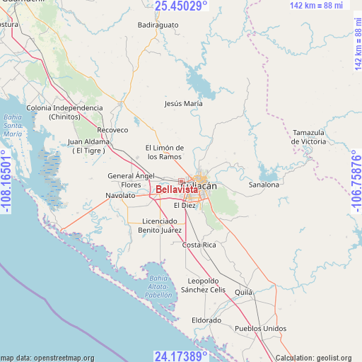
Bellavista GPS coordinates[2]
24° 48' 49.428" North, 107° 27' 42.768" West
| Map corner | latitude | longitude |
|---|---|---|
| Upper-left | 25.45029°, | -108.16501° |
| Center: | 24.81373°, | -107.46188° |
| Lower-right: | 24.17389°, | -106.75876° |
| Map W x H: | 141.9×141.9 km | = 88.2×88.2mi |
| max Lat: | 32.7° ⇑8.5% North |
| Bellavista: | 24.81373° |
| min Lat: | ⇓91.5% South 14.53588° |
| min Long | Bellavista | max Long |
| -117.105° | -107.46188° | -86.73105° |
| W 5.1%⇐ | ⇒94.9% E |
Elevation
Elevation of Bellavista is 34 m = 112 ft, and this is 1219.7 m = 4002 ft below average elevation for this country.
| Max E: |
3497 m = 11473 ft | 87% |
| Avg. | 1253.7 m = 4113 ft | |
| Bellavista | 34 m = 112 ft | |
Min E: |
-1 m = -3 ft | 13% |
See also: Mexico elevation on elevation.city.
Geographical zone
Bellavista is located in North temperate zone (between Tropic of Cancer and the Arctic Circle). Distance of this Northern Tropic circle is 153.1 km =95.1 mi to South.| Distance of | km | miles | from Bellavista |
|---|---|---|---|
| North Pole | 7248 | 4503.7 | to North |
| Arctic Circle | 4642.1 | 2884.5 | to North |
| Tropic Cancer | 153.1 | 95.1 | to South |
| Equator | 2759 | 1714.4 | to South |


Nearby cities:
15 places around Bellavista: (largest is in red/bold)
• Argentina Dos
11.2 km =7 mi,  163°
163°
• Bachigualatito
11.2 km =7 mi,  183°
183°
• Bacurimí
1 km =0.6 mi,  101°
101°
• Campo Balbuena
11.6 km =7.2 mi,  230°
230°
• Culiacancito
7.4 km =4.6 mi,  280°
280°
• Culiacán
7.9 km =4.9 mi,  109°
109°
• Ejido el Quemadito
13.8 km =8.6 mi, 159°
• El Diez
10 km =6.2 mi,  174°
174°
• El Limón de los Ramos
12.7 km =7.9 mi,  330°
330°
• El Ranchito
11.5 km =7.1 mi,  130°
130°
• Estación Rosales
12.2 km =7.6 mi, 282°
• La Bebelama de San Pedro
11.5 km =7.1 mi,  258°
258°
• La Limita de Itaje
10.6 km =6.6 mi,  86°
86°
• La Palmita y Anexos (La Presita)
10.7 km =6.6 mi,  5°
5°
• Los Arredondo (Los Arredondo de San Pedro)
13.4 km =8.3 mi, 255°
Sources, notices
• [Note1] Compared only with cities in Mexico existing in our database
• [Src1] Map data: © OpenStreetMap contributors (CC-BY-SA)
• [Src2] Other city data from geonames.org with taken over terms of usage.
• [Src3] Geographical zone / Annual Mean Temperature by Robert A. Rohde @ Wikipedia
