Paramo geodata
Paramo (Chihuahua) is a populated place; located in Mexico in America/Chihuahua (GMT-6) time zone. With population of 516 people, there are 16314 cities with bigger population in this country. Compared to other cities in Mexico, 97.7% of cities are located further ↓South; 94.6% of cities are located further →East and 79.7% of cities have lower elevation than Paramo. Note1


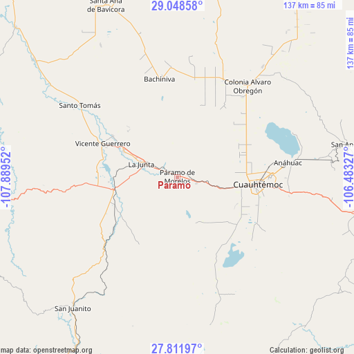
Paramo GPS coordinates[2]
28° 25' 55.488" North, 107° 11' 11.004" West
| Map corner | latitude | longitude |
|---|---|---|
| Upper-left | 29.04858°, | -107.88952° |
| Center: | 28.43208°, | -107.18639° |
| Lower-right: | 27.81197°, | -106.48327° |
| Map W x H: | 137.5×137.5 km | = 85.4×85.4mi |
| max Lat: | 32.7° ⇑2.3% North |
| Paramo: | 28.43208° |
| min Lat: | ⇓97.7% South 14.53588° |
| min Long | Paramo | max Long |
| -117.105° | -107.18639° | -86.73105° |
| W 5.4%⇐ | ⇒94.6% E |
Elevation
Elevation of Paramo is 2134 m = 7001 ft, and this is 880.3 m = 2888 ft above average elevation for this country.
| Max E: |
3497 m = 11473 ft | 20.3% |
| Paramo | 2134 m 7001 ft | |
| Avg. | 1253.7 m = 4113 ft | |
Min E: |
-1 m = -3 ft | 79.7% |
See also: Mexico elevation on elevation.city.
Geographical zone
Paramo is located in North temperate zone (between Tropic of Cancer and the Arctic Circle). Distance of this Northern Tropic circle is 555.4 km =345.1 mi to South.| Distance of | km | miles | from Paramo |
|---|---|---|---|
| North Pole | 6845.7 | 4253.7 | to North |
| Arctic Circle | 4239.8 | 2634.5 | to North |
| Tropic Cancer | 555.4 | 345.1 | to South |
| Equator | 3161.4 | 1964.4 | to South |


Nearby cities:
15 places around Paramo: (largest is in red/bold)
• Adolfo López Mateos
11.8 km =7.3 mi,  289°
289°
• Bachíniva
38 km =23.6 mi,  349°
349°
• Basúchil
23.4 km =14.5 mi,  296°
296°
• Borjas
25.4 km =15.8 mi, 296°
• Campo Número Dos
23.7 km =14.7 mi,  85°
85°
• Cuauhtémoc
31.7 km =19.7 mi, 94°
• Guadalupe Victoria (Santa Lucía)
38.9 km =24.2 mi,  96°
96°
• Guerrero
31.8 km =19.8 mi, 294°
• La Junta
15 km =9.3 mi, 290°
• Pachera
26.5 km =16.5 mi,  231°
231°
• Pedernales
7.8 km =4.8 mi,  107°
107°
• Ranchos de Santiago
8.9 km =5.5 mi,  177°
177°
• Sáenz
17.8 km =11.1 mi, 294°
• Tacuba
29.5 km =18.3 mi,  252°
252°
• Álamos de Cerro Prieto
28.3 km =17.6 mi,  163°
163°
Sources, notices
• [Note1] Compared only with cities in Mexico existing in our database
• [Src1] Map data: © OpenStreetMap contributors (CC-BY-SA)
• [Src2] Other city data from geonames.org with taken over terms of usage.
• [Src3] Geographical zone / Annual Mean Temperature by Robert A. Rohde @ Wikipedia
