Cuatro Ciénegas de Carranza geodata
Cuatro Ciénegas de Carranza (Coahuila) is a seat of a second-order administrative division; located in Mexico in America/Monterrey (GMT-6) time zone. With population of 10,309 people, there are 920 cities with bigger population in this country. Compared to other cities in Mexico, 96.3% of cities are located further ↓South; 81.3% of cities are located further →East and 64.2% of cities have higher elevation than Cuatro Ciénegas de Carranza. Note1
Current local time in Cuatro Ciénegas de Carranza:
08:01 AM, WednesdayDifference from your time zone: hours


Cuatro Ciénegas de Carranza GPS coordinates[2]
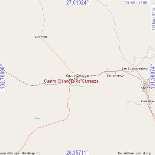
26° 59' 7.512" North, 102° 3' 49.896" West
| Map corner | latitude | longitude |
|---|---|---|
| Upper-left | 27.61024°, | -102.76699° |
| Center: | 26.98542°, | -102.06386° |
| Lower-right: | 26.35711°, | -101.36074° |
| Map W x H: | 139.3×139.3 km | = 86.6×86.6mi |
| max Lat: | 32.7° ⇑3.7% North |
| Cuatro Ciénegas de Carranza: | 26.98542° |
| min Lat: | ⇓96.3% South 14.53588° |
| min Long | Cuatro Ciénega | max Long |
| -117.105° | -102.06386° | -86.73105° |
| W 18.7%⇐ | ⇒81.3% E |
Elevation
Elevation of Cuatro Ciénegas de Carranza is 739 m = 2425 ft, and this is 514.7 m = 1689 ft below average elevation for this country.
| Max E: |
3497 m = 11473 ft | 64.2% |
| Avg. | 1253.7 m = 4113 ft | |
| Cuatro Ciénegas de Carranza | 739 m = 2425 ft | |
Min E: |
-1 m = -3 ft | 35.8% |
See also: Mexico elevation on elevation.city.
Geographical zone
Cuatro Ciénegas de Carranza is located in North temperate zone (between Tropic of Cancer and the Arctic Circle). Distance of this Northern Tropic circle is 394.6 km =245.2 mi to South.| Distance of | km | miles | from Cuatro Ciénegas de Carranza |
|---|---|---|---|
| North Pole | 7006.6 | 4353.7 | to North |
| Arctic Circle | 4400.7 | 2734.5 | to North |
| Tropic Cancer | 394.6 | 245.2 | to South |
| Equator | 3000.5 | 1864.4 | to South |


Nearby cities:
15 places around Cuatro Ciénegas de Carranza: (largest is in red/bold)
• Abasolo
66.7 km =41.4 mi,  70°
70°
• Castaños
66.3 km =41.2 mi,  109°
109°
• Colonia Diana Laura Riojas de Colosio
57.8 km =35.9 mi,  90°
90°
• Escobedo
70.1 km =43.6 mi, 66°
• Frontera
61 km =37.9 mi,  95°
95°
• La Cruz
56.3 km =35 mi, 89°
• Lamadrid
27.6 km =17.1 mi, 74°
• Monclova
64.4 km =40 mi, 97°
• Nadadores
46.8 km =29.1 mi,  84°
84°
• Ocampo
49.2 km =30.6 mi,  318°
318°
• Ocho de Enero
56.3 km =35 mi, 88°
• Primero de Mayo
87.7 km =54.5 mi, 71°
• Sacramento
33.7 km =20.9 mi, 86°
• San Buenaventura
51.7 km =32.1 mi, 80°
• San José de Aura
95.7 km =59.5 mi,  45°
45°
Sources, notices
• [Note1] Compared only with cities in Mexico existing in our database
• [Src1] Map data: © OpenStreetMap contributors (CC-BY-SA)
• [Src2] Other city data from geonames.org with taken over terms of usage.
• [Src3] Geographical zone / Annual Mean Temperature by Robert A. Rohde @ Wikipedia
