Contreras geodata
Contreras (Durango) is a populated place; located in Mexico in America/Monterrey (GMT-6) time zone. With population of 878 people, there are 9946 cities with bigger population in this country. Compared to other cities in Mexico, 90.1% of cities are located further ↓South; 91.1% of cities are located further →East and 67.1% of cities have lower elevation than Contreras. Note1


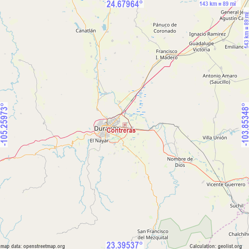
Contreras GPS coordinates[2]
24° 2' 20.796" North, 104° 33' 23.76" West
| Map corner | latitude | longitude |
|---|---|---|
| Upper-left | 24.67964°, | -105.25973° |
| Center: | 24.03911°, | -104.5566° |
| Lower-right: | 23.39537°, | -103.85348° |
| Map W x H: | 142.8×142.8 km | = 88.7×88.7mi |
| max Lat: | 32.7° ⇑9.9% North |
| Contreras: | 24.03911° |
| min Lat: | ⇓90.1% South 14.53588° |
| min Long | Contreras | max Long |
| -117.105° | -104.5566° | -86.73105° |
| W 8.9%⇐ | ⇒91.1% E |
Elevation
Elevation of Contreras is 1871 m = 6138 ft, and this is 617.3 m = 2025 ft above average elevation for this country.
| Max E: |
3497 m = 11473 ft | 32.9% |
| Contreras | 1871 m 6138 ft | |
| Avg. | 1253.7 m = 4113 ft | |
Min E: |
-1 m = -3 ft | 67.1% |
See also: Mexico elevation on elevation.city.
Geographical zone
Contreras is located in North temperate zone (between Tropic of Cancer and the Arctic Circle). Distance of this Northern Tropic circle is 67 km =41.6 mi to South.| Distance of | km | miles | from Contreras |
|---|---|---|---|
| North Pole | 7334.2 | 4557.3 | to North |
| Arctic Circle | 4728.3 | 2938 | to North |
| Tropic Cancer | 67 | 41.6 | to South |
| Equator | 2672.9 | 1660.9 | to South |


Nearby cities:
15 places around Contreras: (largest is in red/bold)
• Aquiles Serdán
11.1 km =6.9 mi,  193°
193°
• Cinco de Febrero
6.7 km =4.2 mi,  51°
51°
• Cinco de Mayo
7.2 km =4.5 mi,  345°
345°
• Dolores Hidalgo
4.5 km =2.8 mi,  202°
202°
• El Arenal
12.8 km =8 mi,  76°
76°
• Gabino Santillán
7.6 km =4.7 mi,  210°
210°
• Hidalgo
13.5 km =8.4 mi, 348°
• José Refugio Salcido
9.2 km =5.7 mi,  154°
154°
• Navacoyán
1.3 km =0.8 mi,  33°
33°
• Parras de la Fuente
5.3 km =3.3 mi, 151°
• Pilar de Zaragoza
13.7 km =8.5 mi, 200°
• Praxedis G. Guerrero Nuevo (La Loma)
11 km =6.8 mi,  184°
184°
• Sebastián Lerdo de Tejada
12.4 km =7.7 mi,  220°
220°
• Victoria de Durango
10.5 km =6.5 mi,  258°
258°
• Villa Montemorelos
9.4 km =5.8 mi,  124°
124°
Sources, notices
• [Note1] Compared only with cities in Mexico existing in our database
• [Src1] Map data: © OpenStreetMap contributors (CC-BY-SA)
• [Src2] Other city data from geonames.org with taken over terms of usage.
• [Src3] Geographical zone / Annual Mean Temperature by Robert A. Rohde @ Wikipedia
