Hidalgo geodata
Hidalgo (Durango) is a populated place; located in Mexico in America/Monterrey (GMT-6) time zone. With population of 1,986 people, there are 4387 cities with bigger population in this country. Compared to other cities in Mexico, 90.3% of cities are located further ↓South; 91.2% of cities are located further →East and 67% of cities have lower elevation than Hidalgo. Note1


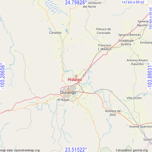
Hidalgo GPS coordinates[2]
24° 9' 30.096" North, 104° 35' 0.348" West
| Map corner | latitude | longitude |
|---|---|---|
| Upper-left | 24.79828°, | -105.28656° |
| Center: | 24.15836°, | -104.58343° |
| Lower-right: | 23.51522°, | -103.88031° |
| Map W x H: | 142.7×142.7 km | = 88.7×88.7mi |
| max Lat: | 32.7° ⇑9.7% North |
| Hidalgo: | 24.15836° |
| min Lat: | ⇓90.3% South 14.53588° |
| min Long | Hidalgo | max Long |
| -117.105° | -104.58343° | -86.73105° |
| W 8.8%⇐ | ⇒91.2% E |
Elevation
Elevation of Hidalgo is 1869 m = 6132 ft, and this is 615.3 m = 2019 ft above average elevation for this country.
| Max E: |
3497 m = 11473 ft | 33% |
| Hidalgo | 1869 m 6132 ft | |
| Avg. | 1253.7 m = 4113 ft | |
Min E: |
-1 m = -3 ft | 67% |
See also: Mexico elevation on elevation.city.
Geographical zone
Hidalgo is located in North temperate zone (between Tropic of Cancer and the Arctic Circle). Distance of this Northern Tropic circle is 80.2 km =49.8 mi to South.| Distance of | km | miles | from Hidalgo |
|---|---|---|---|
| North Pole | 7320.9 | 4549 | to North |
| Arctic Circle | 4715 | 2929.8 | to North |
| Tropic Cancer | 80.2 | 49.8 | to South |
| Equator | 2686.2 | 1669.1 | to South |


Nearby cities:
15 places around Hidalgo: (largest is in red/bold)
• Abraham González
8 km =5 mi,  41°
41°
• Cinco de Febrero
12.1 km =7.5 mi,  138°
138°
• Cinco de Mayo
6.4 km =4 mi,  171°
171°
• Contreras
13.5 km =8.4 mi, 168°
• Dolores Hidalgo
17.4 km =10.8 mi,  176°
176°
• El Arenal
18.4 km =11.4 mi,  124°
124°
• Gabino Santillán
19.8 km =12.3 mi, 183°
• Juan B. Ceballos
10 km =6.2 mi,  302°
302°
• Labor de Guadalupe
1.4 km =0.9 mi,  293°
293°
• Morcillo
12.1 km =7.5 mi,  276°
276°
• Navacoyán
12.7 km =7.9 mi,  164°
164°
• Parras de la Fuente
18.6 km =11.6 mi, 163°
• San Vicente de Chupaderos
13.9 km =8.6 mi,  251°
251°
• Victoria de Durango
17.1 km =10.6 mi,  206°
206°
• Villa Montemorelos
21.3 km =13.2 mi,  150°
150°
Sources, notices
• [Note1] Compared only with cities in Mexico existing in our database
• [Src1] Map data: © OpenStreetMap contributors (CC-BY-SA)
• [Src2] Other city data from geonames.org with taken over terms of usage.
• [Src3] Geographical zone / Annual Mean Temperature by Robert A. Rohde @ Wikipedia
