El Arenal geodata
El Arenal (Durango) is a populated place; located in Mexico in America/Monterrey (GMT-6) time zone. With population of 1,015 people, there are 8582 cities with bigger population in this country. Compared to other cities in Mexico, 90.2% of cities are located further ↓South; 90.8% of cities are located further →East and 66.4% of cities have lower elevation than El Arenal. Note1


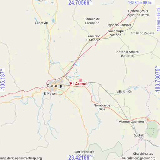
El Arenal GPS coordinates[2]
24° 3' 54.972" North, 104° 26' 1.932" West
| Map corner | latitude | longitude |
|---|---|---|
| Upper-left | 24.70566°, | -105.137° |
| Center: | 24.06527°, | -104.43387° |
| Lower-right: | 23.42166°, | -103.73075° |
| Map W x H: | 142.8×142.8 km | = 88.7×88.7mi |
| max Lat: | 32.7° ⇑9.8% North |
| El Arenal: | 24.06527° |
| min Lat: | ⇓90.2% South 14.53588° |
| min Long | El Arenal | max Long |
| -117.105° | -104.43387° | -86.73105° |
| W 9.2%⇐ | ⇒90.8% E |
Elevation
Elevation of El Arenal is 1860 m = 6102 ft, and this is 606.3 m = 1989 ft above average elevation for this country.
| Max E: |
3497 m = 11473 ft | 33.6% |
| El Arenal | 1860 m 6102 ft | |
| Avg. | 1253.7 m = 4113 ft | |
Min E: |
-1 m = -3 ft | 66.4% |
See also: Mexico elevation on elevation.city.
Geographical zone
El Arenal is located in North temperate zone (between Tropic of Cancer and the Arctic Circle). Distance of this Northern Tropic circle is 69.9 km =43.4 mi to South.| Distance of | km | miles | from El Arenal |
|---|---|---|---|
| North Pole | 7331.3 | 4555.5 | to North |
| Arctic Circle | 4725.4 | 2936.2 | to North |
| Tropic Cancer | 69.9 | 43.4 | to South |
| Equator | 2675.8 | 1662.7 | to South |


Nearby cities:
15 places around El Arenal: (largest is in red/bold)
• Cinco de Febrero
7.3 km =4.5 mi,  279°
279°
• Cinco de Mayo
14.8 km =9.2 mi,  285°
285°
• Contreras
12.8 km =8 mi,  256°
256°
• Dolores Hidalgo
15.8 km =9.8 mi,  243°
243°
• Gabino Santillán
18.9 km =11.7 mi, 240°
• Hidalgo
18.4 km =11.4 mi,  304°
304°
• Héroe de Nacozari
7.2 km =4.5 mi,  134°
134°
• Ignacio López Rayón
16.8 km =10.4 mi,  202°
202°
• Independencia y Libertad
9.8 km =6.1 mi,  103°
103°
• José Refugio Salcido
14.1 km =8.8 mi,  217°
217°
• Navacoyán
11.9 km =7.4 mi, 261°
• Parras de la Fuente
12.5 km =7.8 mi,  232°
232°
• Primero de Mayo
9.4 km =5.8 mi,  114°
114°
• Tuitán
18.9 km =11.7 mi, 101°
• Villa Montemorelos
9.5 km =5.9 mi,  209°
209°
Sources, notices
• [Note1] Compared only with cities in Mexico existing in our database
• [Src1] Map data: © OpenStreetMap contributors (CC-BY-SA)
• [Src2] Other city data from geonames.org with taken over terms of usage.
• [Src3] Geographical zone / Annual Mean Temperature by Robert A. Rohde @ Wikipedia
