Cofradia geodata
Cofradia (Jalisco) is a populated place; located in Mexico in America/Mexico_City (GMT-6) time zone. With population of 1,772 people, there are 4897 cities with bigger population in this country. Compared to other cities in Mexico, 67.2% of cities are located further ↓South; 88.6% of cities are located further →East and 52% of cities have lower elevation than Cofradia. Note1


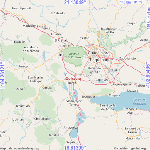
Cofradia GPS coordinates[2]
20° 28' 23.52" North, 103° 33' 29.088" West
| Map corner | latitude | longitude |
|---|---|---|
| Upper-left | 21.13049°, | -104.26121° |
| Center: | 20.4732°, | -103.55808° |
| Lower-right: | 19.81309°, | -102.85496° |
| Map W x H: | 146.5×146.5 km | = 91×91mi |
| max Lat: | 32.7° ⇑32.8% North |
| Cofradia: | 20.4732° |
| min Lat: | ⇓67.2% South 14.53588° |
| min Long | Cofradia | max Long |
| -117.105° | -103.55808° | -86.73105° |
| W 11.4%⇐ | ⇒88.6% E |
Elevation
Elevation of Cofradia is 1523 m = 4997 ft, and this is 269.3 m = 884 ft above average elevation for this country.
| Max E: |
3497 m = 11473 ft | 48% |
| Cofradia | 1523 m 4997 ft | |
| Avg. | 1253.7 m = 4113 ft | |
Min E: |
-1 m = -3 ft | 52% |
See also: Mexico elevation on elevation.city.
Geographical zone
Cofradia is located in North Torrid zone (between Equator and Tropic of Cancer). Distance of this Northern Tropic circle is 329.5 km =204.7 mi to North.| Distance of | km | miles | from Cofradia |
|---|---|---|---|
| North Pole | 7730.7 | 4803.6 | to North |
| Arctic Circle | 5124.8 | 3184.4 | to North |
| Tropic Cancer | 329.5 | 204.7 | to North |
| Equator | 2276.4 | 1414.5 | to South |


Nearby cities:
15 places around Cofradia: (largest is in red/bold)
• Acatlán de Juárez
6.6 km =4.1 mi,  210°
210°
• Bellavista
9.3 km =5.8 mi,  242°
242°
• Buenavista
4.4 km =2.7 mi,  117°
117°
• Cruz Vieja
3 km =1.9 mi,  326°
326°
• El Molino
9.7 km =6 mi,  166°
166°
• El Plan
7.9 km =4.9 mi,  219°
219°
• La Villita
10.2 km =6.3 mi,  318°
318°
• Lomas de San Agustín
11.2 km =7 mi,  57°
57°
• Lomas de Santa Anita (Colinas de Santa Anita)
7.3 km =4.5 mi,  65°
65°
• Nicolás R Casillas
12.6 km =7.8 mi,  49°
49°
• San Isidro Mazatepec
7.9 km =4.9 mi,  314°
314°
• Santa Cruz de la Loma (Tepetates)
1.9 km =1.2 mi,  27°
27°
• Santa Cruz de las Flores
5.8 km =3.6 mi,  81°
81°
• Tlajomulco de Zúñiga
11.6 km =7.2 mi,  89°
89°
• Villa de los Niños
7.6 km =4.7 mi, 166°
Sources, notices
• [Note1] Compared only with cities in Mexico existing in our database
• [Src1] Map data: © OpenStreetMap contributors (CC-BY-SA)
• [Src2] Other city data from geonames.org with taken over terms of usage.
• [Src3] Geographical zone / Annual Mean Temperature by Robert A. Rohde @ Wikipedia
