La Villita geodata
La Villita (Jalisco) is a populated place; located in Mexico in America/Mexico_City (GMT-6) time zone. With population of 686 people, there are 12663 cities with bigger population in this country. Compared to other cities in Mexico, 68.7% of cities are located further ↓South; 88.8% of cities are located further →East and 51.5% of cities have lower elevation than La Villita. Note1


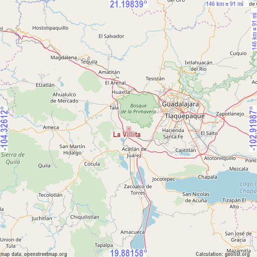
La Villita GPS coordinates[2]
20° 32' 29.04" North, 103° 37' 22.764" West
| Map corner | latitude | longitude |
|---|---|---|
| Upper-left | 21.19839°, | -104.32612° |
| Center: | 20.5414°, | -103.62299° |
| Lower-right: | 19.88158°, | -102.91987° |
| Map W x H: | 146.4×146.4 km | = 91×91mi |
| max Lat: | 32.7° ⇑31.3% North |
| La Villita: | 20.5414° |
| min Lat: | ⇓68.7% South 14.53588° |
| min Long | La Villita | max Long |
| -117.105° | -103.62299° | -86.73105° |
| W 11.2%⇐ | ⇒88.8% E |
Elevation
Elevation of La Villita is 1508 m = 4948 ft, and this is 254.3 m = 834 ft above average elevation for this country.
| Max E: |
3497 m = 11473 ft | 48.5% |
| La Villita | 1508 m 4948 ft | |
| Avg. | 1253.7 m = 4113 ft | |
Min E: |
-1 m = -3 ft | 51.5% |
See also: Mexico elevation on elevation.city.
Geographical zone
La Villita is located in North Torrid zone (between Equator and Tropic of Cancer). Distance of this Northern Tropic circle is 321.9 km =200 mi to North.| Distance of | km | miles | from La Villita |
|---|---|---|---|
| North Pole | 7723.1 | 4798.9 | to North |
| Arctic Circle | 5117.2 | 3179.7 | to North |
| Tropic Cancer | 321.9 | 200 | to North |
| Equator | 2284 | 1419.2 | to South |


Nearby cities:
15 places around La Villita: (largest is in red/bold)
• Acatlán de Juárez
13.6 km =8.5 mi,  165°
165°
• Ahuisculco
8.9 km =5.5 mi,  290°
290°
• Bellavista
12 km =7.5 mi,  187°
187°
• Buenavista
14.4 km =8.9 mi,  132°
132°
• Cofradia
10.2 km =6.3 mi,  138°
138°
• Cruz Vieja
7.2 km =4.5 mi, 134°
• Cuxpala
3 km =1.9 mi,  310°
310°
• El Plan
13.8 km =8.6 mi, 172°
• Lomas de Santa Anita (Colinas de Santa Anita)
14.2 km =8.8 mi,  108°
108°
• Navajas
6 km =3.7 mi,  261°
261°
• San Isidro Mazatepec
2.3 km =1.4 mi,  153°
153°
• San Juan de los Arcos
12.3 km =7.6 mi, 305°
• Santa Cruz de la Loma (Tepetates)
9.7 km =6 mi, 127°
• Santa Cruz de las Flores
14.2 km =8.8 mi,  118°
118°
• Villa Corona
14.6 km =9.1 mi,  197°
197°
Sources, notices
• [Note1] Compared only with cities in Mexico existing in our database
• [Src1] Map data: © OpenStreetMap contributors (CC-BY-SA)
• [Src2] Other city data from geonames.org with taken over terms of usage.
• [Src3] Geographical zone / Annual Mean Temperature by Robert A. Rohde @ Wikipedia
