Cruz Vieja geodata
Cruz Vieja (Jalisco) is a populated place; located in Mexico in America/Mexico_City (GMT-6) time zone. With population of 534 people, there are 15868 cities with bigger population in this country. Compared to other cities in Mexico, 67.7% of cities are located further ↓South; 88.6% of cities are located further →East and 51.3% of cities have lower elevation than Cruz Vieja. Note1


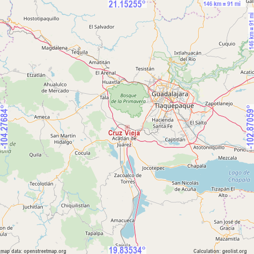
Cruz Vieja GPS coordinates[2]
20° 29' 43.296" North, 103° 34' 25.356" West
| Map corner | latitude | longitude |
|---|---|---|
| Upper-left | 21.15255°, | -104.27684° |
| Center: | 20.49536°, | -103.57371° |
| Lower-right: | 19.83534°, | -102.87059° |
| Map W x H: | 146.5×146.5 km | = 91×91mi |
| max Lat: | 32.7° ⇑32.3% North |
| Cruz Vieja: | 20.49536° |
| min Lat: | ⇓67.7% South 14.53588° |
| min Long | Cruz Vieja | max Long |
| -117.105° | -103.57371° | -86.73105° |
| W 11.4%⇐ | ⇒88.6% E |
Elevation
Elevation of Cruz Vieja is 1499 m = 4918 ft, and this is 245.3 m = 805 ft above average elevation for this country.
| Max E: |
3497 m = 11473 ft | 48.7% |
| Cruz Vieja | 1499 m 4918 ft | |
| Avg. | 1253.7 m = 4113 ft | |
Min E: |
-1 m = -3 ft | 51.3% |
See also: Mexico elevation on elevation.city.
Geographical zone
Cruz Vieja is located in North Torrid zone (between Equator and Tropic of Cancer). Distance of this Northern Tropic circle is 327 km =203.2 mi to North.| Distance of | km | miles | from Cruz Vieja |
|---|---|---|---|
| North Pole | 7728.2 | 4802.1 | to North |
| Arctic Circle | 5122.3 | 3182.8 | to North |
| Tropic Cancer | 327 | 203.2 | to North |
| Equator | 2278.9 | 1416 | to South |


Nearby cities:
15 places around Cruz Vieja: (largest is in red/bold)
• Acatlán de Juárez
8.3 km =5.2 mi,  192°
192°
• Bellavista
9.5 km =5.9 mi,  224°
224°
• Buenavista
7.2 km =4.5 mi,  129°
129°
• Cofradia
3 km =1.9 mi,  146°
146°
• Cuxpala
10.3 km =6.4 mi,  313°
313°
• El Plan
9.2 km =5.7 mi,  201°
201°
• La Villita
7.2 km =4.5 mi, 314°
• Lomas de San Agustín
11.6 km =7.2 mi,  72°
72°
• Lomas de Santa Anita (Colinas de Santa Anita)
8.3 km =5.2 mi,  85°
85°
• Navajas
11.8 km =7.3 mi,  290°
290°
• Nicolás R Casillas
12.5 km =7.8 mi,  63°
63°
• San Isidro Mazatepec
5.1 km =3.2 mi, 306°
• Santa Cruz de la Loma (Tepetates)
2.6 km =1.6 mi,  107°
107°
• Santa Cruz de las Flores
7.6 km =4.7 mi,  102°
102°
• Villa de los Niños
10.4 km =6.5 mi,  161°
161°
Sources, notices
• [Note1] Compared only with cities in Mexico existing in our database
• [Src1] Map data: © OpenStreetMap contributors (CC-BY-SA)
• [Src2] Other city data from geonames.org with taken over terms of usage.
• [Src3] Geographical zone / Annual Mean Temperature by Robert A. Rohde @ Wikipedia
