Cherán geodata
Cherán (Michoacán) is a seat of a second-order administrative division; located in Mexico in America/Mexico_City (GMT-6) time zone. With population of 14,245 people, there are 678 cities with bigger population in this country. Compared to other cities in Mexico, 50% of cities are located further ↓South; 80.7% of cities are located further →East and 89.7% of cities have lower elevation than Cherán. Note1


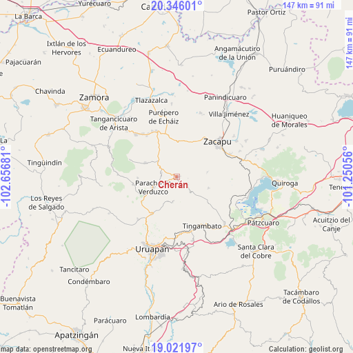
Cherán GPS coordinates[2]
19° 41' 7.296" North, 101° 57' 13.248" West
| Map corner | latitude | longitude |
|---|---|---|
| Upper-left | 20.34601°, | -102.65681° |
| Center: | 19.68536°, | -101.95368° |
| Lower-right: | 19.02197°, | -101.25056° |
| Map W x H: | 147.2×147.2 km | = 91.5×91.5mi |
| max Lat: | 32.7° ⇑50% North |
| Cherán: | 19.68536° |
| min Lat: | ⇓50% South 14.53588° |
| min Long | Cherán | max Long |
| -117.105° | -101.95368° | -86.73105° |
| W 19.3%⇐ | ⇒80.7% E |
Elevation
Elevation of Cherán is 2395 m = 7858 ft, and this is 1141.3 m = 3744 ft above average elevation for this country.
| Max E: |
3497 m = 11473 ft | 10.3% |
| Cherán | 2395 m 7858 ft | |
| Avg. | 1253.7 m = 4113 ft | |
Min E: |
-1 m = -3 ft | 89.7% |
See also: Mexico elevation on elevation.city.
Geographical zone
Cherán is located in North Torrid zone (between Equator and Tropic of Cancer). Distance of this Northern Tropic circle is 417.1 km =259.2 mi to North.| Distance of | km | miles | from Cherán |
|---|---|---|---|
| North Pole | 7818.3 | 4858.1 | to North |
| Arctic Circle | 5212.4 | 3238.8 | to North |
| Tropic Cancer | 417.1 | 259.2 | to North |
| Equator | 2188.8 | 1360.1 | to South |


Nearby cities:
15 places around Cherán: (largest is in red/bold)
• Ahuirán
12.7 km =7.9 mi,  260°
260°
• Arantepacua
10.1 km =6.3 mi,  188°
188°
• Aranza
7.7 km =4.8 mi,  252°
252°
• Casimiro Leco (El Cerecito)
9.2 km =5.7 mi,  349°
349°
• Cherán Atzicuirín (Cheranástico)
6.7 km =4.2 mi,  284°
284°
• Comachuén
13.7 km =8.5 mi,  157°
157°
• El Pueblito
15.2 km =9.4 mi,  9°
9°
• La Mojonera
12.8 km =8 mi,  80°
80°
• Nahuatzén
5.1 km =3.2 mi,  131°
131°
• Paracho de Verduzco
10.8 km =6.7 mi, 247°
• Quinceo
11.2 km =7 mi,  205°
205°
• San Isidro
13.9 km =8.6 mi,  110°
110°
• Sevina
8.4 km =5.2 mi,  138°
138°
• Tanaco
14.7 km =9.1 mi,  294°
294°
• Turícuaro
12.8 km =8 mi,  172°
172°
Sources, notices
• [Note1] Compared only with cities in Mexico existing in our database
• [Src1] Map data: © OpenStreetMap contributors (CC-BY-SA)
• [Src2] Other city data from geonames.org with taken over terms of usage.
• [Src3] Geographical zone / Annual Mean Temperature by Robert A. Rohde @ Wikipedia
