San Isidro geodata
San Isidro (Michoacán) is a populated place; located in Mexico in America/Mexico_City (GMT-6) time zone. With population of 879 people, there are 9939 cities with bigger population in this country. Compared to other cities in Mexico, 51% of cities are located further ↑North; 79.9% of cities are located further →East and 97.3% of cities have lower elevation than San Isidro. Note1


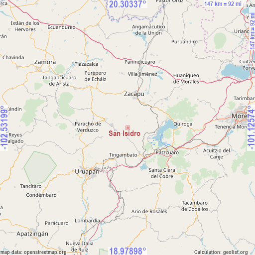
San Isidro GPS coordinates[2]
19° 38' 33.144" North, 101° 49' 43.896" West
| Map corner | latitude | longitude |
|---|---|---|
| Upper-left | 20.30337°, | -102.53199° |
| Center: | 19.64254°, | -101.82886° |
| Lower-right: | 18.97898°, | -101.12574° |
| Map W x H: | 147.3×147.3 km | = 91.5×91.5mi |
| max Lat: | 32.7° ⇑51% North |
| San Isidro: | 19.64254° |
| min Lat: | ⇓49% South 14.53588° |
| min Long | San Isidro | max Long |
| -117.105° | -101.82886° | -86.73105° |
| W 20.1%⇐ | ⇒79.9% E |
Elevation
Elevation of San Isidro is 2703 m = 8868 ft, and this is 1449.3 m = 4755 ft above average elevation for this country.
| Max E: |
3497 m = 11473 ft | 2.7% |
| San Isidro | 2703 m 8868 ft | |
| Avg. | 1253.7 m = 4113 ft | |
Min E: |
-1 m = -3 ft | 97.3% |
See also: Mexico elevation on elevation.city.
Geographical zone
San Isidro is located in North Torrid zone (between Equator and Tropic of Cancer). Distance of this Northern Tropic circle is 421.9 km =262.2 mi to North.| Distance of | km | miles | from San Isidro |
|---|---|---|---|
| North Pole | 7823 | 4861 | to North |
| Arctic Circle | 5217.1 | 3241.8 | to North |
| Tropic Cancer | 421.9 | 262.2 | to North |
| Equator | 2184 | 1357.1 | to South |


Nearby cities:
15 places around San Isidro: (largest is in red/bold)
• Arantepacua
15.5 km =9.6 mi,  250°
250°
• Capula
7.1 km =4.4 mi,  25°
25°
• Cherán
13.9 km =8.6 mi,  290°
290°
• Comachuén
11.2 km =7 mi,  224°
224°
• Erongarícuaro
12.8 km =8 mi,  117°
117°
• La Mojonera
6.8 km =4.2 mi,  355°
355°
• Lázaro Cárdenas (Colonia de Lázaro Cárdenas)
9.7 km =6 mi,  63°
63°
• Nahuatzén
9.3 km =5.8 mi,  278°
278°
• Napízaro
15 km =9.3 mi,  109°
109°
• Pichátaro
8.1 km =5 mi,  163°
163°
• Santa María Huiramangaro (San Juan Tumbio)
15.9 km =9.9 mi, 155°
• Sevina
7.7 km =4.8 mi,  258°
258°
• Tingambato
15.9 km =9.9 mi,  189°
189°
• Turícuaro
13.9 km =8.6 mi,  234°
234°
• Uricho
14.2 km =8.8 mi, 123°
Sources, notices
• [Note1] Compared only with cities in Mexico existing in our database
• [Src1] Map data: © OpenStreetMap contributors (CC-BY-SA)
• [Src2] Other city data from geonames.org with taken over terms of usage.
• [Src3] Geographical zone / Annual Mean Temperature by Robert A. Rohde @ Wikipedia
