Nahuatzén geodata
Nahuatzén (Michoacán) is a seat of a second-order administrative division; located in Mexico in America/Mexico_City (GMT-6) time zone. With population of 10,283 people, there are 922 cities with bigger population in this country. Compared to other cities in Mexico, 50.8% of cities are located further ↑North; 80.4% of cities are located further →East and 90.2% of cities have lower elevation than Nahuatzén. Note1


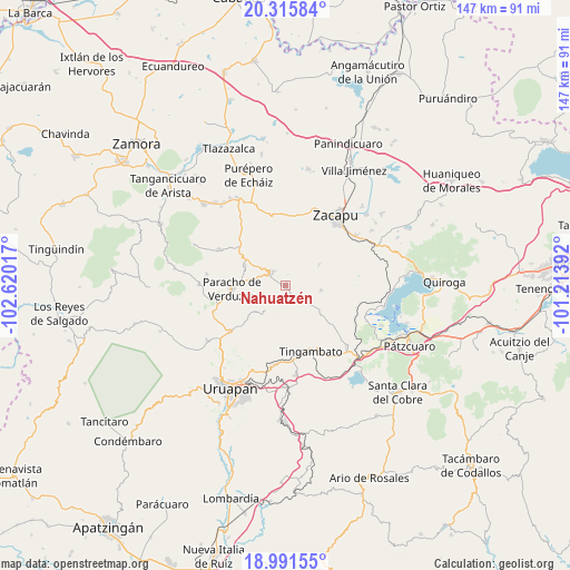
Nahuatzén GPS coordinates[2]
19° 39' 18.216" North, 101° 55' 1.344" West
| Map corner | latitude | longitude |
|---|---|---|
| Upper-left | 20.31584°, | -102.62017° |
| Center: | 19.65506°, | -101.91704° |
| Lower-right: | 18.99155°, | -101.21392° |
| Map W x H: | 147.2×147.2 km | = 91.5×91.5mi |
| max Lat: | 32.7° ⇑50.8% North |
| Nahuatzén: | 19.65506° |
| min Lat: | ⇓49.2% South 14.53588° |
| min Long | Nahuatzén | max Long |
| -117.105° | -101.91704° | -86.73105° |
| W 19.6%⇐ | ⇒80.4% E |
Elevation
Elevation of Nahuatzén is 2415 m = 7923 ft, and this is 1161.3 m = 3810 ft above average elevation for this country.
| Max E: |
3497 m = 11473 ft | 9.8% |
| Nahuatzén | 2415 m 7923 ft | |
| Avg. | 1253.7 m = 4113 ft | |
Min E: |
-1 m = -3 ft | 90.2% |
See also: Mexico elevation on elevation.city.
Geographical zone
Nahuatzén is located in North Torrid zone (between Equator and Tropic of Cancer). Distance of this Northern Tropic circle is 420.5 km =261.3 mi to North.| Distance of | km | miles | from Nahuatzén |
|---|---|---|---|
| North Pole | 7821.6 | 4860.1 | to North |
| Arctic Circle | 5215.7 | 3240.9 | to North |
| Tropic Cancer | 420.5 | 261.3 | to North |
| Equator | 2185.4 | 1357.9 | to South |


Nearby cities:
15 places around Nahuatzén: (largest is in red/bold)
• Ahuirán
16.4 km =10.2 mi,  274°
274°
• Arantepacua
8.5 km =5.3 mi,  219°
219°
• Aranza
11.2 km =7 mi,  275°
275°
• Capula
13.2 km =8.2 mi,  67°
67°
• Casimiro Leco (El Cerecito)
13.6 km =8.5 mi,  335°
335°
• Cherán
5.1 km =3.2 mi,  311°
311°
• Cherán Atzicuirín (Cheranástico)
11.5 km =7.1 mi,  295°
295°
• Comachuén
9.4 km =5.8 mi,  171°
171°
• La Mojonera
10.3 km =6.4 mi,  58°
58°
• Paracho de Verduzco
13.8 km =8.6 mi, 266°
• Pichátaro
14.7 km =9.1 mi,  128°
128°
• Quinceo
11 km =6.8 mi,  232°
232°
• San Isidro
9.3 km =5.8 mi,  98°
98°
• Sevina
3.4 km =2.1 mi,  149°
149°
• Turícuaro
9.6 km =6 mi,  192°
192°
Sources, notices
• [Note1] Compared only with cities in Mexico existing in our database
• [Src1] Map data: © OpenStreetMap contributors (CC-BY-SA)
• [Src2] Other city data from geonames.org with taken over terms of usage.
• [Src3] Geographical zone / Annual Mean Temperature by Robert A. Rohde @ Wikipedia
