Carmen geodata
Carmen (Nuevo León) is a seat of a second-order administrative division; located in Mexico in America/Monterrey (GMT-6) time zone. With population of 9,568 people, there are 1001 cities with bigger population in this country. Compared to other cities in Mexico, 95.1% of cities are located further ↓South; 68.1% of cities are located further →East and 68.4% of cities have higher elevation than Carmen. Note1


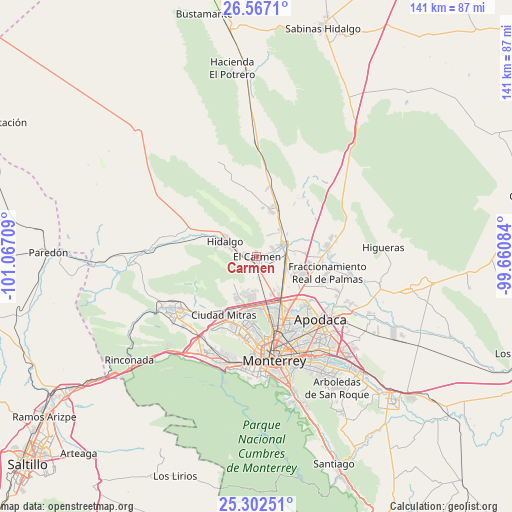
Carmen GPS coordinates[2]
25° 56' 11.4" North, 100° 21' 50.256" West
| Map corner | latitude | longitude |
|---|---|---|
| Upper-left | 26.5671°, | -101.06709° |
| Center: | 25.9365°, | -100.36396° |
| Lower-right: | 25.30251°, | -99.66084° |
| Map W x H: | 140.6×140.6 km | = 87.4×87.4mi |
| max Lat: | 32.7° ⇑4.9% North |
| Carmen: | 25.9365° |
| min Lat: | ⇓95.1% South 14.53588° |
| min Long | Carmen | max Long |
| -117.105° | -100.36396° | -86.73105° |
| W 31.9%⇐ | ⇒68.1% E |
Elevation
Elevation of Carmen is 505 m = 1657 ft, and this is 748.7 m = 2456 ft below average elevation for this country.
| Max E: |
3497 m = 11473 ft | 68.4% |
| Avg. | 1253.7 m = 4113 ft | |
| Carmen | 505 m = 1657 ft | |
Min E: |
-1 m = -3 ft | 31.6% |
See also: Mexico elevation on elevation.city.
Geographical zone
Carmen is located in North temperate zone (between Tropic of Cancer and the Arctic Circle). Distance of this Northern Tropic circle is 277.9 km =172.7 mi to South.| Distance of | km | miles | from Carmen |
|---|---|---|---|
| North Pole | 7123.2 | 4426.1 | to North |
| Arctic Circle | 4517.3 | 2806.9 | to North |
| Tropic Cancer | 277.9 | 172.7 | to South |
| Equator | 2883.9 | 1792 | to South |


Nearby cities:
15 places around Carmen: (largest is in red/bold)
• Abasolo
3.4 km =2.1 mi,  288°
288°
• Alberto Villarreal
4.8 km =3 mi,  279°
279°
• Alianza Real
9.6 km =6 mi,  191°
191°
• Buena Vista
9.4 km =5.8 mi,  177°
177°
• Ciudad Satélite del Norte
10.2 km =6.3 mi,  103°
103°
• Emiliano Zapata
8.8 km =5.5 mi,  109°
109°
• Hidalgo
9.5 km =5.9 mi, 294°
• Las Torres
4.9 km =3 mi,  69°
69°
• Los Morales
13 km =8.1 mi,  19°
19°
• Los Villarreales
13.3 km =8.3 mi, 17°
• Monclova Segundo Sector
13.9 km =8.6 mi, 193°
• Praderas de San Francisco
13.7 km =8.5 mi,  196°
196°
• Salinas Victoria
7.9 km =4.9 mi, 67°
• Simeprodeso (Colectivo Nuevo)
11.8 km =7.3 mi,  142°
142°
• Unión Agropecuarios Lázaro Cárdenas del Norte
11.8 km =7.3 mi, 189°
Sources, notices
• [Note1] Compared only with cities in Mexico existing in our database
• [Src1] Map data: © OpenStreetMap contributors (CC-BY-SA)
• [Src2] Other city data from geonames.org with taken over terms of usage.
• [Src3] Geographical zone / Annual Mean Temperature by Robert A. Rohde @ Wikipedia
