Los Villarreales geodata
Los Villarreales (Nuevo León) is a populated place; located in Mexico in America/Monterrey (GMT-6) time zone. With population of 811 people, there are 10778 cities with bigger population in this country. Compared to other cities in Mexico, 95.4% of cities are located further ↓South; 67.7% of cities are located further →East and 69.1% of cities have higher elevation than Los Villarreales. Note1


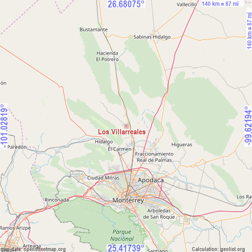
Los Villarreales GPS coordinates[2]
26° 3' 2.772" North, 100° 19' 30.216" West
| Map corner | latitude | longitude |
|---|---|---|
| Upper-left | 26.68075°, | -101.02819° |
| Center: | 26.05077°, | -100.32506° |
| Lower-right: | 25.41739°, | -99.62194° |
| Map W x H: | 140.5×140.5 km | = 87.3×87.3mi |
| max Lat: | 32.7° ⇑4.6% North |
| Los Villarreales: | 26.05077° |
| min Lat: | ⇓95.4% South 14.53588° |
| min Long | Los Villarreale | max Long |
| -117.105° | -100.32506° | -86.73105° |
| W 32.3%⇐ | ⇒67.7% E |
Elevation
Elevation of Los Villarreales is 465 m = 1526 ft, and this is 788.7 m = 2588 ft below average elevation for this country.
| Max E: |
3497 m = 11473 ft | 69.1% |
| Avg. | 1253.7 m = 4113 ft | |
| Los Villarreales | 465 m = 1526 ft | |
Min E: |
-1 m = -3 ft | 30.9% |
See also: Mexico elevation on elevation.city.
Geographical zone
Los Villarreales is located in North temperate zone (between Tropic of Cancer and the Arctic Circle). Distance of this Northern Tropic circle is 290.7 km =180.6 mi to South.| Distance of | km | miles | from Los Villarreales |
|---|---|---|---|
| North Pole | 7110.5 | 4418.3 | to North |
| Arctic Circle | 4504.6 | 2799 | to North |
| Tropic Cancer | 290.7 | 180.6 | to South |
| Equator | 2896.6 | 1799.9 | to South |


Nearby cities:
15 places around Los Villarreales: (largest is in red/bold)
• Abasolo
13.6 km =8.5 mi,  211°
211°
• Alberto Villarreal
14.7 km =9.1 mi,  216°
216°
• Carmen
13.3 km =8.3 mi,  197°
197°
• Ciudad Satélite del Norte
16.3 km =10.1 mi,  158°
158°
• Ciénega de Flores
19.1 km =11.9 mi,  124°
124°
• Emiliano Zapata
16.2 km =10.1 mi, 164°
• Hidalgo
15.3 km =9.5 mi,  235°
235°
• Las Torres
11 km =6.8 mi,  176°
176°
• Los Morales
0.6 km =0.4 mi,  142°
142°
• Mamulique
12.4 km =7.7 mi,  51°
51°
• Paseos del Roble
20.4 km =12.7 mi, 142°
• Portal de las Salinas
19.7 km =12.2 mi,  112°
112°
• Real del Sol
19.1 km =11.9 mi,  130°
130°
• Salinas Victoria
10.3 km =6.4 mi, 160°
• Villas de Alcalá
20.5 km =12.7 mi, 137°
Sources, notices
• [Note1] Compared only with cities in Mexico existing in our database
• [Src1] Map data: © OpenStreetMap contributors (CC-BY-SA)
• [Src2] Other city data from geonames.org with taken over terms of usage.
• [Src3] Geographical zone / Annual Mean Temperature by Robert A. Rohde @ Wikipedia
