Capácuaro geodata
Capácuaro (Michoacán) is a populated place; located in Mexico in America/Mexico_City (GMT-6) time zone. With population of 7,424 people, there are 1252 cities with bigger population in this country. Compared to other cities in Mexico, 53.1% of cities are located further ↑North; 81.2% of cities are located further →East and 85.1% of cities have lower elevation than Capácuaro. Note1


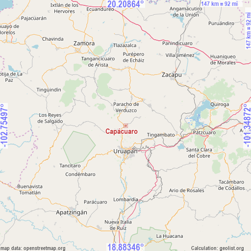
Capácuaro GPS coordinates[2]
19° 32' 50.676" North, 102° 3' 6.624" West
| Map corner | latitude | longitude |
|---|---|---|
| Upper-left | 20.20864°, | -102.75497° |
| Center: | 19.54741°, | -102.05184° |
| Lower-right: | 18.88346°, | -101.34872° |
| Map W x H: | 147.3×147.3 km | = 91.5×91.5mi |
| max Lat: | 32.7° ⇑53.1% North |
| Capácuaro: | 19.54741° |
| min Lat: | ⇓46.9% South 14.53588° |
| min Long | Capácuaro | max Long |
| -117.105° | -102.05184° | -86.73105° |
| W 18.8%⇐ | ⇒81.2% E |
Elevation
Elevation of Capácuaro is 2262 m = 7421 ft, and this is 1008.3 m = 3308 ft above average elevation for this country.
| Max E: |
3497 m = 11473 ft | 14.9% |
| Capácuaro | 2262 m 7421 ft | |
| Avg. | 1253.7 m = 4113 ft | |
Min E: |
-1 m = -3 ft | 85.1% |
See also: Mexico elevation on elevation.city.
Geographical zone
Capácuaro is located in North Torrid zone (between Equator and Tropic of Cancer). Distance of this Northern Tropic circle is 432.5 km =268.7 mi to North.| Distance of | km | miles | from Capácuaro |
|---|---|---|---|
| North Pole | 7833.6 | 4867.6 | to North |
| Arctic Circle | 5227.7 | 3248.3 | to North |
| Tropic Cancer | 432.5 | 268.7 | to North |
| Equator | 2173.5 | 1350.5 | to South |


Nearby cities:
15 places around Capácuaro: (largest is in red/bold)
• Ahuirán
13.4 km =8.3 mi,  350°
350°
• Arantepacua
10.2 km =6.3 mi,  58°
58°
• Aranza
13.3 km =8.3 mi,  12°
12°
• Caltzontzín
14.6 km =9.1 mi,  161°
161°
• La Basília
9.5 km =5.9 mi,  188°
188°
• Nurío
14.6 km =9.1 mi,  326°
326°
• Paracho de Verduzco
11.1 km =6.9 mi,  1°
1°
• Pomacuarán
9.9 km =6.2 mi, 327°
• Quinceo
7.6 km =4.7 mi,  46°
46°
• San Andrés Coru
14.4 km =8.9 mi,  128°
128°
• San Felipe de los Herreros
15.6 km =9.7 mi,  299°
299°
• San Lorenzo
6.4 km =4 mi,  250°
250°
• Toreo Bajo (El Toreo Bajo)
12.5 km =7.8 mi, 156°
• Turícuaro
12.3 km =7.6 mi,  77°
77°
• Uruapan
15.2 km =9.4 mi,  181°
181°
Sources, notices
• [Note1] Compared only with cities in Mexico existing in our database
• [Src1] Map data: © OpenStreetMap contributors (CC-BY-SA)
• [Src2] Other city data from geonames.org with taken over terms of usage.
• [Src3] Geographical zone / Annual Mean Temperature by Robert A. Rohde @ Wikipedia
