Uruapan geodata
Uruapan (Michoacán) is a seat of a second-order administrative division; located in Mexico in America/Mexico_City (GMT-6) time zone. With population of 264,439 people, there are 71 cities with bigger population in this country. Compared to other cities in Mexico, 56.1% of cities are located further ↑North; 81.3% of cities are located further →East and 56% of cities have lower elevation than Uruapan. Note1


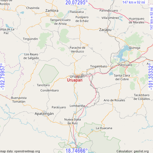
Uruapan GPS coordinates[2]
19° 24' 40.176" North, 102° 3' 23.184" West
| Map corner | latitude | longitude |
|---|---|---|
| Upper-left | 20.07295°, | -102.75957° |
| Center: | 19.41116°, | -102.05644° |
| Lower-right: | 18.74666°, | -101.35332° |
| Map W x H: | 147.5×147.5 km | = 91.7×91.7mi |
| max Lat: | 32.7° ⇑56.1% North |
| Uruapan: | 19.41116° |
| min Lat: | ⇓43.9% South 14.53588° |
| min Long | Uruapan | max Long |
| -117.105° | -102.05644° | -86.73105° |
| W 18.7%⇐ | ⇒81.3% E |
Elevation
Elevation of Uruapan is 1620 m = 5315 ft, and this is 366.3 m = 1202 ft above average elevation for this country.
| Max E: |
3497 m = 11473 ft | 44% |
| Uruapan | 1620 m 5315 ft | |
| Avg. | 1253.7 m = 4113 ft | |
Min E: |
-1 m = -3 ft | 56% |
See also: Uruapan elevation on elevation.city.
Geographical zone
Uruapan is located in North Torrid zone (between Equator and Tropic of Cancer). Distance of this Northern Tropic circle is 447.6 km =278.1 mi to North.| Distance of | km | miles | from Uruapan |
|---|---|---|---|
| North Pole | 7848.7 | 4877 | to North |
| Arctic Circle | 5242.9 | 3257.8 | to North |
| Tropic Cancer | 447.6 | 278.1 | to North |
| Equator | 2158.3 | 1341.1 | to South |


Nearby cities:
15 places around Uruapan: (largest is in red/bold)
• Arandín
6.8 km =4.2 mi,  261°
261°
• Caltzontzín
5.4 km =3.4 mi,  75°
75°
• Caracha
14.4 km =8.9 mi, 79°
• Cutzato (Cuisato)
9.6 km =6 mi,  238°
238°
• El Arroyo Colorado
6.9 km =4.3 mi,  179°
179°
• Jucutacato
4.4 km =2.7 mi,  212°
212°
• La Basília
5.8 km =3.6 mi,  350°
350°
• Nuevo San Juan Parangaricutiro
7.8 km =4.8 mi,  276°
276°
• Patuán
14.8 km =9.2 mi,  98°
98°
• San Andrés Coru
13.2 km =8.2 mi,  62°
62°
• San Lorenzo
14.1 km =8.8 mi,  336°
336°
• Santa Rosa (Santa Bárbara)
3.8 km =2.4 mi,  145°
145°
• Tahuejo
14.5 km =9 mi,  135°
135°
• Toreo Bajo (El Toreo Bajo)
6.6 km =4.1 mi, 55°
• Zirimícuaro
10.3 km =6.4 mi,  92°
92°
Sources, notices
• [Note1] Compared only with cities in Mexico existing in our database
• [Src1] Map data: © OpenStreetMap contributors (CC-BY-SA)
• [Src2] Other city data from geonames.org with taken over terms of usage.
• [Src3] Geographical zone / Annual Mean Temperature by Robert A. Rohde @ Wikipedia
