Campuzano geodata
Campuzano (Guanajuato) is a populated place; located in Mexico in America/Mexico_City (GMT-6) time zone. With population of 597 people, there are 14400 cities with bigger population in this country. Compared to other cities in Mexico, 75.1% of cities are located further ↓South; 74.6% of cities are located further →East and 75.3% of cities have lower elevation than Campuzano. Note1


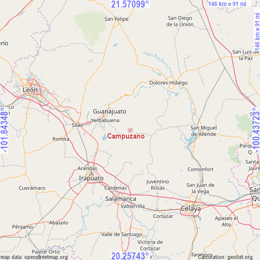
Campuzano GPS coordinates[2]
20° 54' 56.34" North, 101° 8' 25.26" West
| Map corner | latitude | longitude |
|---|---|---|
| Upper-left | 21.57099°, | -101.84348° |
| Center: | 20.91565°, | -101.14035° |
| Lower-right: | 20.25743°, | -100.43723° |
| Map W x H: | 146.1×146.1 km | = 90.8×90.8mi |
| max Lat: | 32.7° ⇑24.9% North |
| Campuzano: | 20.91565° |
| min Lat: | ⇓75.1% South 14.53588° |
| min Long | Campuzano | max Long |
| -117.105° | -101.14035° | -86.73105° |
| W 25.4%⇐ | ⇒74.6% E |
Elevation
Elevation of Campuzano is 2036 m = 6680 ft, and this is 782.3 m = 2567 ft above average elevation for this country.
| Max E: |
3497 m = 11473 ft | 24.7% |
| Campuzano | 2036 m 6680 ft | |
| Avg. | 1253.7 m = 4113 ft | |
Min E: |
-1 m = -3 ft | 75.3% |
See also: Mexico elevation on elevation.city.
Geographical zone
Campuzano is located in North Torrid zone (between Equator and Tropic of Cancer). Distance of this Northern Tropic circle is 280.3 km =174.2 mi to North.| Distance of | km | miles | from Campuzano |
|---|---|---|---|
| North Pole | 7681.5 | 4773.1 | to North |
| Arctic Circle | 5075.6 | 3153.8 | to North |
| Tropic Cancer | 280.3 | 174.2 | to North |
| Equator | 2325.6 | 1445.1 | to South |


Nearby cities:
15 places around Campuzano: (largest is in red/bold)
• Cajones
13.2 km =8.2 mi,  267°
267°
• Calderones
12.1 km =7.5 mi,  312°
312°
• Coyote
12.6 km =7.8 mi,  240°
240°
• El Tejabán
9.8 km =6.1 mi,  253°
253°
• Fraccionamiento Arboledas
15.1 km =9.4 mi,  286°
286°
• La Cantera
7.5 km =4.7 mi,  84°
84°
• La Presita
14 km =8.7 mi,  276°
276°
• La Sauceda
5.6 km =3.5 mi, 249°
• La Trinidad
11.9 km =7.4 mi, 267°
• Puentecillas
14.5 km =9 mi, 277°
• San Isidro
14.1 km =8.8 mi, 287°
• San José de Allende
12.9 km =8 mi,  120°
120°
• San José del Rodeo
7.9 km =4.9 mi, 274°
• San Martín de Terreros
11.9 km =7.4 mi,  92°
92°
• Yerbabuena
14.9 km =9.3 mi, 290°
Sources, notices
• [Note1] Compared only with cities in Mexico existing in our database
• [Src1] Map data: © OpenStreetMap contributors (CC-BY-SA)
• [Src2] Other city data from geonames.org with taken over terms of usage.
• [Src3] Geographical zone / Annual Mean Temperature by Robert A. Rohde @ Wikipedia
