Caitime geodata
Caitime (Sinaloa) is a populated place; located in Mexico in America/Mazatlan (GMT-7) time zone. With population of 541 people, there are 15692 cities with bigger population in this country. Compared to other cities in Mexico, 92.2% of cities are located further ↓South; 95.6% of cities are located further →East and 80.1% of cities have higher elevation than Caitime. Note1


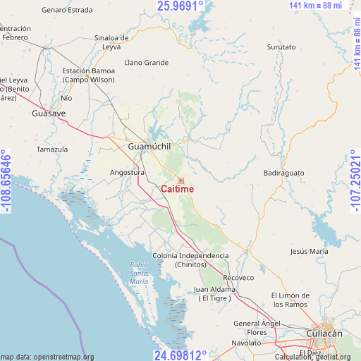
Caitime GPS coordinates[2]
25° 20' 7.008" North, 107° 57' 11.988" West
| Map corner | latitude | longitude |
|---|---|---|
| Upper-left | 25.9691°, | -108.65646° |
| Center: | 25.33528°, | -107.95333° |
| Lower-right: | 24.69812°, | -107.25021° |
| Map W x H: | 141.3×141.3 km | = 87.8×87.8mi |
| max Lat: | 32.7° ⇑7.8% North |
| Caitime: | 25.33528° |
| min Lat: | ⇓92.2% South 14.53588° |
| min Long | Caitime | max Long |
| -117.105° | -107.95333° | -86.73105° |
| W 4.4%⇐ | ⇒95.6% E |
Elevation
Elevation of Caitime is 93 m = 305 ft, and this is 1160.7 m = 3808 ft below average elevation for this country.
| Max E: |
3497 m = 11473 ft | 80.1% |
| Avg. | 1253.7 m = 4113 ft | |
| Caitime | 93 m = 305 ft | |
Min E: |
-1 m = -3 ft | 19.9% |
See also: Mexico elevation on elevation.city.
Geographical zone
Caitime is located in North temperate zone (between Tropic of Cancer and the Arctic Circle). Distance of this Northern Tropic circle is 211.1 km =131.2 mi to South.| Distance of | km | miles | from Caitime |
|---|---|---|---|
| North Pole | 7190 | 4467.7 | to North |
| Arctic Circle | 4584.2 | 2848.5 | to North |
| Tropic Cancer | 211.1 | 131.2 | to South |
| Equator | 2817 | 1750.4 | to South |


Nearby cities:
15 places around Caitime: (largest is in red/bold)
• Alhuey
18.4 km =11.4 mi,  284°
284°
• Angostura
21.1 km =13.1 mi, 279°
• Capomos
19.5 km =12.1 mi,  295°
295°
• Colonia Agrícola México (Palmitas)
25.1 km =15.6 mi,  178°
178°
• El Salitre
21.2 km =13.2 mi, 302°
• El Taballal
12.4 km =7.7 mi,  313°
313°
• El Ébano
23.2 km =14.4 mi,  266°
266°
• Estación Acatita
8.8 km =5.5 mi,  248°
248°
• Guamúchil
18.5 km =11.5 mi,  317°
317°
• Gustavo Díaz Ordaz
16.1 km =10 mi,  241°
241°
• La Esperanza
23.5 km =14.6 mi, 273°
• La Palma
21.3 km =13.2 mi, 284°
• Mocorito
16.7 km =10.4 mi,  11°
11°
• San Isidro
19.4 km =12.1 mi, 302°
• Tultita
15.7 km =9.8 mi, 320°
Sources, notices
• [Note1] Compared only with cities in Mexico existing in our database
• [Src1] Map data: © OpenStreetMap contributors (CC-BY-SA)
• [Src2] Other city data from geonames.org with taken over terms of usage.
• [Src3] Geographical zone / Annual Mean Temperature by Robert A. Rohde @ Wikipedia
