Barrón geodata
Barrón (Sinaloa) is a populated place; located in Mexico in America/Mazatlan (GMT-7) time zone. With population of 1,792 people, there are 4851 cities with bigger population in this country. Compared to other cities in Mexico, 88.2% of cities are located further ↓South; 94% of cities are located further →East and 98.1% of cities have higher elevation than Barrón. Note1


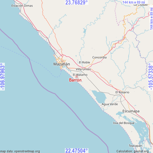
Barrón GPS coordinates[2]
23° 7' 23.592" North, 106° 16' 35.4" West
| Map corner | latitude | longitude |
|---|---|---|
| Upper-left | 23.76829°, | -106.97963° |
| Center: | 23.12322°, | -106.2765° |
| Lower-right: | 22.47504°, | -105.57338° |
| Map W x H: | 143.8×143.8 km | = 89.4×89.4mi |
| max Lat: | 32.7° ⇑11.8% North |
| Barrón: | 23.12322° |
| min Lat: | ⇓88.2% South 14.53588° |
| min Long | Barrón | max Long |
| -117.105° | -106.2765° | -86.73105° |
| W 6%⇐ | ⇒94% E |
Elevation
Elevation of Barrón is 8 m = 26 ft, and this is 1245.7 m = 4087 ft below average elevation for this country.
| Max E: |
3497 m = 11473 ft | 98.1% |
| Avg. | 1253.7 m = 4113 ft | |
| Barrón | 8 m = 26 ft | |
Min E: |
-1 m = -3 ft | 1.9% |
See also: Mexico elevation on elevation.city.
Geographical zone
Barrón is located in North Torrid zone (between Equator and Tropic of Cancer). Distance of this Northern Tropic circle is 34.9 km =21.7 mi to North.| Distance of | km | miles | from Barrón |
|---|---|---|---|
| North Pole | 7436 | 4620.5 | to North |
| Arctic Circle | 4830.1 | 3001.3 | to North |
| Tropic Cancer | 34.9 | 21.7 | to North |
| Equator | 2571.1 | 1597.6 | to South |


Nearby cities:
15 places around Barrón: (largest is in red/bold)
• Ejido Gregorio Vázquez Moreno (San Joachín)
22.6 km =14 mi,  140°
140°
• El Bajío
21.3 km =13.2 mi,  16°
16°
• El Castillo
10.3 km =6.4 mi,  321°
321°
• El Huajote
22.3 km =13.9 mi,  88°
88°
• El Roble
15.4 km =9.6 mi,  27°
27°
• El Vainillo
9.3 km =5.8 mi,  9°
9°
• El Walamo
3.7 km =2.3 mi,  59°
59°
• Escamillas
16.8 km =10.4 mi, 10°
• Fraccionamiento los Ángeles
9.1 km =5.7 mi, 322°
• Lomas de Monterrey
14.8 km =9.2 mi, 7°
• Los Pozos
17.9 km =11.1 mi,  134°
134°
• Malpica
20.8 km =12.9 mi,  45°
45°
• Mazatlán
18 km =11.2 mi,  312°
312°
• San Francisquito
13.5 km =8.4 mi, 10°
• Villa Unión
9.4 km =5.8 mi,  38°
38°
Sources, notices
• [Note1] Compared only with cities in Mexico existing in our database
• [Src1] Map data: © OpenStreetMap contributors (CC-BY-SA)
• [Src2] Other city data from geonames.org with taken over terms of usage.
• [Src3] Geographical zone / Annual Mean Temperature by Robert A. Rohde @ Wikipedia
