Bachigualatito geodata
Bachigualatito (Sinaloa) is a populated place; located in Mexico in America/Mazatlan (GMT-7) time zone. With population of 1,032 people, there are 8443 cities with bigger population in this country. Compared to other cities in Mexico, 91.2% of cities are located further ↓South; 94.9% of cities are located further →East and 89% of cities have higher elevation than Bachigualatito. Note1


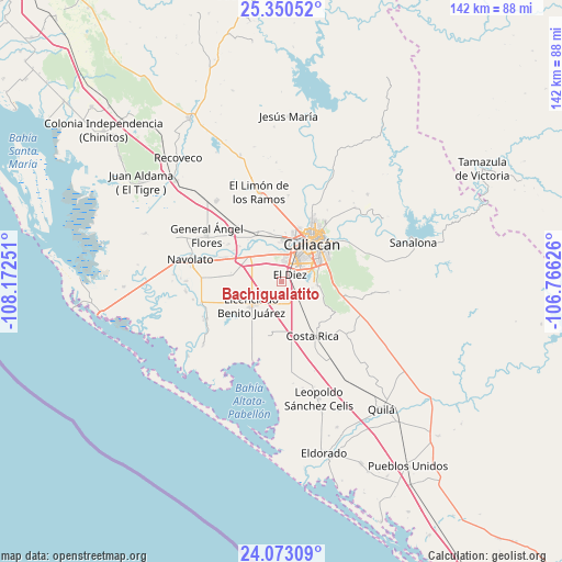
Bachigualatito GPS coordinates[2]
24° 42' 48.384" North, 107° 28' 9.768" West
| Map corner | latitude | longitude |
|---|---|---|
| Upper-left | 25.35052°, | -108.17251° |
| Center: | 24.71344°, | -107.46938° |
| Lower-right: | 24.07309°, | -106.76626° |
| Map W x H: | 142×142 km | = 88.2×88.2mi |
| max Lat: | 32.7° ⇑8.8% North |
| Bachigualatito: | 24.71344° |
| min Lat: | ⇓91.2% South 14.53588° |
| min Long | Bachigualatito | max Long |
| -117.105° | -107.46938° | -86.73105° |
| W 5.1%⇐ | ⇒94.9% E |
Elevation
Elevation of Bachigualatito is 27 m = 89 ft, and this is 1226.7 m = 4025 ft below average elevation for this country.
| Max E: |
3497 m = 11473 ft | 89% |
| Avg. | 1253.7 m = 4113 ft | |
| Bachigualatito | 27 m = 89 ft | |
Min E: |
-1 m = -3 ft | 11% |
See also: Mexico elevation on elevation.city.
Geographical zone
Bachigualatito is located in North temperate zone (between Tropic of Cancer and the Arctic Circle). Distance of this Northern Tropic circle is 142 km =88.2 mi to South.| Distance of | km | miles | from Bachigualatito |
|---|---|---|---|
| North Pole | 7259.2 | 4510.7 | to North |
| Arctic Circle | 4653.3 | 2891.4 | to North |
| Tropic Cancer | 142 | 88.2 | to South |
| Equator | 2747.9 | 1707.5 | to South |


Nearby cities:
15 places around Bachigualatito: (largest is in red/bold)
• Argentina Dos
4.1 km =2.5 mi,  84°
84°
• Bacurimí
11.1 km =6.9 mi,  8°
8°
• Batallón
13.5 km =8.4 mi,  295°
295°
• Bellavista
11.2 km =7 mi,  3°
3°
• Campo Balbuena
8.9 km =5.5 mi,  294°
294°
• Culiacán
11.9 km =7.4 mi,  43°
43°
• Ejido el Quemadito
5.8 km =3.6 mi,  107°
107°
• El Diez
2.1 km =1.3 mi,  56°
56°
• El Ranchito
10.1 km =6.3 mi,  68°
68°
• La Bebelama de San Pedro
13.7 km =8.5 mi,  310°
310°
• La Curva (La Curva de San Pedro)
12.9 km =8 mi,  276°
276°
• Licenciado Benito Juárez (Campo Gobierno)
9.9 km =6.2 mi,  230°
230°
• Lo de Jesús (Campo Romero)
8.5 km =5.3 mi,  244°
244°
• Nuevo Centro de Población Ejidal el 30
14.1 km =8.8 mi,  144°
144°
• Villa Juárez
9.4 km =5.8 mi, 229°
Sources, notices
• [Note1] Compared only with cities in Mexico existing in our database
• [Src1] Map data: © OpenStreetMap contributors (CC-BY-SA)
• [Src2] Other city data from geonames.org with taken over terms of usage.
• [Src3] Geographical zone / Annual Mean Temperature by Robert A. Rohde @ Wikipedia
