Atotonilco el Bajo geodata
Atotonilco el Bajo (Jalisco) is a populated place; located in Mexico in America/Mexico_City (GMT-6) time zone. With population of 2,466 people, there are 3586 cities with bigger population in this country. Compared to other cities in Mexico, 64.6% of cities are located further ↓South; 89% of cities are located further →East and 51.6% of cities have higher elevation than Atotonilco el Bajo. Note1


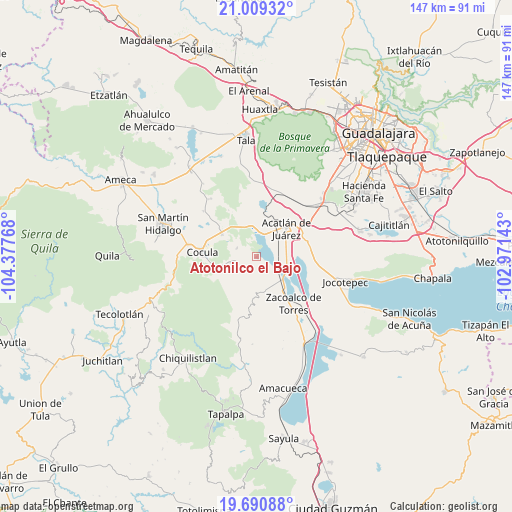
Atotonilco el Bajo GPS coordinates[2]
20° 21' 5.436" North, 103° 40' 28.38" West
| Map corner | latitude | longitude |
|---|---|---|
| Upper-left | 21.00932°, | -104.37768° |
| Center: | 20.35151°, | -103.67455° |
| Lower-right: | 19.69088°, | -102.97143° |
| Map W x H: | 146.6×146.6 km | = 91.1×91.1mi |
| max Lat: | 32.7° ⇑35.4% North |
| Atotonilco el Bajo: | 20.35151° |
| min Lat: | ⇓64.6% South 14.53588° |
| min Long | Atotonilco el B | max Long |
| -117.105° | -103.67455° | -86.73105° |
| W 11%⇐ | ⇒89% E |
Elevation
Elevation of Atotonilco el Bajo is 1357 m = 4452 ft, and this is 103.3 m = 339 ft above average elevation for this country.
| Max E: |
3497 m = 11473 ft | 51.6% |
| Atotonilco el Bajo | 1357 m 4452 ft | |
| Avg. | 1253.7 m = 4113 ft | |
Min E: |
-1 m = -3 ft | 48.4% |
See also: Mexico elevation on elevation.city.
Geographical zone
Atotonilco el Bajo is located in North Torrid zone (between Equator and Tropic of Cancer). Distance of this Northern Tropic circle is 343 km =213.1 mi to North.| Distance of | km | miles | from Atotonilco el Bajo |
|---|---|---|---|
| North Pole | 7744.2 | 4812 | to North |
| Arctic Circle | 5138.3 | 3192.8 | to North |
| Tropic Cancer | 343 | 213.1 | to North |
| Equator | 2262.9 | 1406.1 | to South |


Nearby cities:
15 places around Atotonilco el Bajo: (largest is in red/bold)
• Acatlán de Juárez
11.8 km =7.3 mi,  47°
47°
• Barranca de Otates (Barranca de Otatán)
9.3 km =5.8 mi,  173°
173°
• Barranca de Santa Clara
10.8 km =6.7 mi, 169°
• Bellavista
10 km =6.2 mi,  22°
22°
• Benito Juárez
10.7 km =6.6 mi,  134°
134°
• Buenavista
7.9 km =4.9 mi,  257°
257°
• El Molino
15.1 km =9.4 mi,  74°
74°
• El Plan
10.3 km =6.4 mi,  43°
43°
• Estipa
5.2 km =3.2 mi,  282°
282°
• General Andrés Figueroa
8.6 km =5.3 mi, 127°
• Juan Gil Preciado
6 km =3.7 mi,  293°
293°
• San José de los Pozos
10.9 km =6.8 mi,  91°
91°
• Santa Teresa
11.7 km =7.3 mi, 255°
• Villa Corona
7.2 km =4.5 mi,  8°
8°
• Villa de los Niños
15.1 km =9.4 mi, 66°
Sources, notices
• [Note1] Compared only with cities in Mexico existing in our database
• [Src1] Map data: © OpenStreetMap contributors (CC-BY-SA)
• [Src2] Other city data from geonames.org with taken over terms of usage.
• [Src3] Geographical zone / Annual Mean Temperature by Robert A. Rohde @ Wikipedia
