Estipa geodata
Estipa (Jalisco) is a populated place; located in Mexico in America/Mexico_City (GMT-6) time zone. With population of 2,618 people, there are 3386 cities with bigger population in this country. Compared to other cities in Mexico, 64.8% of cities are located further ↓South; 89.1% of cities are located further →East and 51.1% of cities have higher elevation than Estipa. Note1


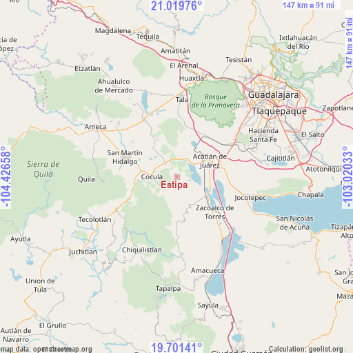
Estipa GPS coordinates[2]
20° 21' 43.164" North, 103° 43' 24.42" West
| Map corner | latitude | longitude |
|---|---|---|
| Upper-left | 21.01976°, | -104.42658° |
| Center: | 20.36199°, | -103.72345° |
| Lower-right: | 19.70141°, | -103.02033° |
| Map W x H: | 146.6×146.6 km | = 91.1×91.1mi |
| max Lat: | 32.7° ⇑35.2% North |
| Estipa: | 20.36199° |
| min Lat: | ⇓64.8% South 14.53588° |
| min Long | Estipa | max Long |
| -117.105° | -103.72345° | -86.73105° |
| W 10.9%⇐ | ⇒89.1% E |
Elevation
Elevation of Estipa is 1379 m = 4524 ft, and this is 125.3 m = 411 ft above average elevation for this country.
| Max E: |
3497 m = 11473 ft | 51.1% |
| Estipa | 1379 m 4524 ft | |
| Avg. | 1253.7 m = 4113 ft | |
Min E: |
-1 m = -3 ft | 48.9% |
See also: Mexico elevation on elevation.city.
Geographical zone
Estipa is located in North Torrid zone (between Equator and Tropic of Cancer). Distance of this Northern Tropic circle is 341.9 km =212.4 mi to North.| Distance of | km | miles | from Estipa |
|---|---|---|---|
| North Pole | 7743 | 4811.3 | to North |
| Arctic Circle | 5137.1 | 3192 | to North |
| Tropic Cancer | 341.9 | 212.4 | to North |
| Equator | 2264 | 1406.8 | to South |


Nearby cities:
15 places around Estipa: (largest is in red/bold)
• Acatlán de Juárez
15.4 km =9.6 mi,  64°
64°
• Atotonilco el Bajo
5.2 km =3.2 mi,  102°
102°
• Barranca de Otates (Barranca de Otatán)
12.1 km =7.5 mi,  149°
149°
• Barranca de Santa Clara
13.8 km =8.6 mi, 149°
• Bellavista
12 km =7.5 mi,  48°
48°
• Buenavista
3.9 km =2.4 mi,  222°
222°
• Cocula
10.3 km =6.4 mi,  271°
271°
• El Crucero de Santa María
14.6 km =9.1 mi,  279°
279°
• El Plan
13.7 km =8.5 mi, 62°
• General Andrés Figueroa
13.5 km =8.4 mi,  118°
118°
• Juan Gil Preciado
1.3 km =0.8 mi,  340°
340°
• La Sauceda
13.3 km =8.3 mi,  319°
319°
• Santa María
14.1 km =8.8 mi,  287°
287°
• Santa Teresa
7.5 km =4.7 mi,  236°
236°
• Villa Corona
8.6 km =5.3 mi, 46°
Sources, notices
• [Note1] Compared only with cities in Mexico existing in our database
• [Src1] Map data: © OpenStreetMap contributors (CC-BY-SA)
• [Src2] Other city data from geonames.org with taken over terms of usage.
• [Src3] Geographical zone / Annual Mean Temperature by Robert A. Rohde @ Wikipedia
