Gambara geodata
Gambara (Michoacán) is a populated place; located in Mexico in America/Mexico_City (GMT-6) time zone. With population of 3,017 people, there are 2979 cities with bigger population in this country. Compared to other cities in Mexico, 66.2% of cities are located further ↑North; 81.6% of cities are located further →East and 73.3% of cities have higher elevation than Gambara. Note1


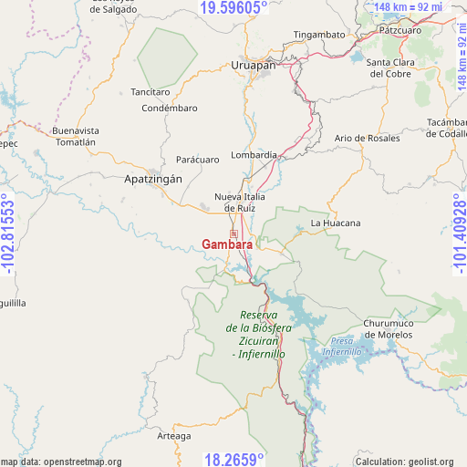
Gambara GPS coordinates[2]
18° 55' 56.28" North, 102° 6' 44.64" West
| Map corner | latitude | longitude |
|---|---|---|
| Upper-left | 19.59605°, | -102.81553° |
| Center: | 18.9323°, | -102.1124° |
| Lower-right: | 18.2659°, | -101.40928° |
| Map W x H: | 147.9×147.9 km | = 91.9×91.9mi |
| max Lat: | 32.7° ⇑66.2% North |
| Gambara: | 18.9323° |
| min Lat: | ⇓33.8% South 14.53588° |
| min Long | Gambara | max Long |
| -117.105° | -102.1124° | -86.73105° |
| W 18.4%⇐ | ⇒81.6% E |
Elevation
Elevation of Gambara is 279 m = 915 ft, and this is 974.7 m = 3198 ft below average elevation for this country.
| Max E: |
3497 m = 11473 ft | 73.3% |
| Avg. | 1253.7 m = 4113 ft | |
| Gambara | 279 m = 915 ft | |
Min E: |
-1 m = -3 ft | 26.7% |
See also: Mexico elevation on elevation.city.
Geographical zone
Gambara is located in North Torrid zone (between Equator and Tropic of Cancer). Distance of this Northern Tropic circle is 500.8 km =311.2 mi to North.| Distance of | km | miles | from Gambara |
|---|---|---|---|
| North Pole | 7902 | 4910.1 | to North |
| Arctic Circle | 5296.1 | 3290.8 | to North |
| Tropic Cancer | 500.8 | 311.2 | to North |
| Equator | 2105.1 | 1308 | to South |


Nearby cities:
15 places around Gambara: (largest is in red/bold)
• Antúnez
13.3 km =8.3 mi,  313°
313°
• Antúnez (Morelos)
13.1 km =8.1 mi, 312°
• Buenos Aires
17.4 km =10.8 mi,  335°
335°
• Cuatro Caminos
6.3 km =3.9 mi,  8°
8°
• El Ceñidor
11.3 km =7 mi, 313°
• El Chauz
8.9 km =5.5 mi,  120°
120°
• El Guaco
16.1 km =10 mi,  21°
21°
• El Letrero
3.5 km =2.2 mi,  3°
3°
• Estación Nueva Italia
15.2 km =9.4 mi, 10°
• Las Crucitas
13.3 km =8.3 mi,  254°
254°
• Las Yeguas
17.5 km =10.9 mi,  260°
260°
• Los Pozos
9.7 km =6 mi, 252°
• Nueva Italia de Ruiz
10.5 km =6.5 mi, 11°
• Nuevo Capirio
7.6 km =4.7 mi,  185°
185°
• Zicuirán
16.3 km =10.1 mi,  111°
111°
Sources, notices
• [Note1] Compared only with cities in Mexico existing in our database
• [Src1] Map data: © OpenStreetMap contributors (CC-BY-SA)
• [Src2] Other city data from geonames.org with taken over terms of usage.
• [Src3] Geographical zone / Annual Mean Temperature by Robert A. Rohde @ Wikipedia
