Álvaro Obregón geodata
Álvaro Obregón (Michoacán) is a seat of a second-order administrative division; located in Mexico in America/Mexico_City (GMT-6) time zone. With population of 8,807 people, there are 1077 cities with bigger population in this country. Compared to other cities in Mexico, 53.3% of cities are located further ↓South; 73.7% of cities are located further →East and 67.6% of cities have lower elevation than Álvaro Obregón. Note1


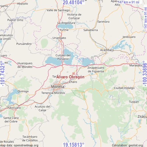
Álvaro Obregón GPS coordinates[2]
19° 49' 15.456" North, 101° 2' 24.288" West
| Map corner | latitude | longitude |
|---|---|---|
| Upper-left | 20.48104°, | -101.74321° |
| Center: | 19.82096°, | -101.04008° |
| Lower-right: | 19.15813°, | -100.33696° |
| Map W x H: | 147.1×147.1 km | = 91.4×91.4mi |
| max Lat: | 32.7° ⇑46.7% North |
| Álvaro Obregón: | 19.82096° |
| min Lat: | ⇓53.3% South 14.53588° |
| min Long | Álvaro Obregó | max Long |
| -117.105° | -101.04008° | -86.73105° |
| W 26.3%⇐ | ⇒73.7% E |
Elevation
Elevation of Álvaro Obregón is 1881 m = 6171 ft, and this is 627.3 m = 2058 ft above average elevation for this country.
| Max E: |
3497 m = 11473 ft | 32.4% |
| Álvaro Obregón | 1881 m 6171 ft | |
| Avg. | 1253.7 m = 4113 ft | |
Min E: |
-1 m = -3 ft | 67.6% |
See also: Mexico elevation on elevation.city.
Geographical zone
Álvaro Obregón is located in North Torrid zone (between Equator and Tropic of Cancer). Distance of this Northern Tropic circle is 402 km =249.8 mi to North.| Distance of | km | miles | from Álvaro Obregón |
|---|---|---|---|
| North Pole | 7803.2 | 4848.7 | to North |
| Arctic Circle | 5197.3 | 3229.5 | to North |
| Tropic Cancer | 402 | 249.8 | to North |
| Equator | 2203.9 | 1369.4 | to South |


Nearby cities:
15 places around Álvaro Obregón: (largest is in red/bold)
• Charo
7.9 km =4.9 mi,  184°
184°
• Colonia Benito Juárez (Chapitiro)
7.6 km =4.7 mi,  58°
58°
• Colonia Miguel Hidalgo
7.5 km =4.7 mi,  238°
238°
• Colonia del Triunfo (La Tepacua)
7 km =4.3 mi,  92°
92°
• Cuparátaro
6.1 km =3.8 mi,  302°
302°
• El Calvario
2.9 km =1.8 mi,  216°
216°
• Emiliano Zapata
7.1 km =4.4 mi,  330°
330°
• Indaparapeo
8.3 km =5.2 mi,  116°
116°
• La Noria
8.4 km =5.2 mi,  285°
285°
• Las Trojes
7.2 km =4.5 mi,  346°
346°
• Lázaro Cárdenas (La Purísima)
5.7 km =3.5 mi,  18°
18°
• Plan de las Palmas
5.1 km =3.2 mi,  83°
83°
• San Antonio Corrales (Nuevo Coronillas)
5.2 km =3.2 mi,  185°
185°
• Tzintzimeo
8.5 km =5.3 mi,  49°
49°
• Uruétaro
6 km =3.7 mi, 235°
Sources, notices
• [Note1] Compared only with cities in Mexico existing in our database
• [Src1] Map data: © OpenStreetMap contributors (CC-BY-SA)
• [Src2] Other city data from geonames.org with taken over terms of usage.
• [Src3] Geographical zone / Annual Mean Temperature by Robert A. Rohde @ Wikipedia
