Charo geodata
Charo (Michoacán) is a populated place; located in Mexico in America/Mexico_City (GMT-6) time zone. With population of 5,207 people, there are 1775 cities with bigger population in this country. Compared to other cities in Mexico, 51.5% of cities are located further ↓South; 73.8% of cities are located further →East and 68% of cities have lower elevation than Charo. Note1


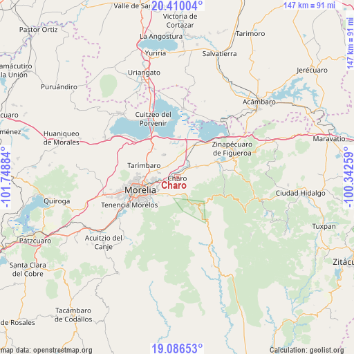
Charo GPS coordinates[2]
19° 44' 58.776" North, 101° 2' 44.556" West
| Map corner | latitude | longitude |
|---|---|---|
| Upper-left | 20.41004°, | -101.74884° |
| Center: | 19.74966°, | -101.04571° |
| Lower-right: | 19.08653°, | -100.34259° |
| Map W x H: | 147.2×147.2 km | = 91.5×91.5mi |
| max Lat: | 32.7° ⇑48.5% North |
| Charo: | 19.74966° |
| min Lat: | ⇓51.5% South 14.53588° |
| min Long | Charo | max Long |
| -117.105° | -101.04571° | -86.73105° |
| W 26.2%⇐ | ⇒73.8% E |
Elevation
Elevation of Charo is 1891 m = 6204 ft, and this is 637.3 m = 2091 ft above average elevation for this country.
| Max E: |
3497 m = 11473 ft | 32% |
| Charo | 1891 m 6204 ft | |
| Avg. | 1253.7 m = 4113 ft | |
Min E: |
-1 m = -3 ft | 68% |
See also: Mexico elevation on elevation.city.
Geographical zone
Charo is located in North Torrid zone (between Equator and Tropic of Cancer). Distance of this Northern Tropic circle is 410 km =254.8 mi to North.| Distance of | km | miles | from Charo |
|---|---|---|---|
| North Pole | 7811.1 | 4853.6 | to North |
| Arctic Circle | 5205.2 | 3234.4 | to North |
| Tropic Cancer | 410 | 254.8 | to North |
| Equator | 2196 | 1364.5 | to South |


Nearby cities:
15 places around Charo: (largest is in red/bold)
• Atapaneo
7.4 km =4.6 mi,  260°
260°
• Cañadas del Bosque
5.7 km =3.5 mi,  243°
243°
• Colonia José Vasconcelos
6.7 km =4.2 mi,  280°
280°
• Colonia Miguel Hidalgo
7.1 km =4.4 mi,  304°
304°
• El Calvario
5.7 km =3.5 mi,  348°
348°
• El Cuitzillo Grande
8.2 km =5.1 mi,  294°
294°
• Fraccionamiento Misión del Valle
8.1 km =5 mi, 282°
• Francisco I. Madero (El Pantano)
5.8 km =3.6 mi,  162°
162°
• Irapeo
6.4 km =4 mi,  191°
191°
• La Goleta
3.9 km =2.4 mi,  252°
252°
• San Antonio Corrales (Nuevo Coronillas)
2.8 km =1.7 mi,  2°
2°
• Unión de Progreso (Lomas de Irapeo)
8 km =5 mi,  180°
180°
• Uruétaro
6.3 km =3.9 mi,  315°
315°
• Zurumbeneo
6.6 km =4.1 mi,  146°
146°
• Álvaro Obregón
7.9 km =4.9 mi, 4°
Sources, notices
• [Note1] Compared only with cities in Mexico existing in our database
• [Src1] Map data: © OpenStreetMap contributors (CC-BY-SA)
• [Src2] Other city data from geonames.org with taken over terms of usage.
• [Src3] Geographical zone / Annual Mean Temperature by Robert A. Rohde @ Wikipedia
