Agostitlán geodata
Agostitlán (Michoacán) is a populated place; located in Mexico in America/Mexico_City (GMT-6) time zone. With population of 4,048 people, there are 2252 cities with bigger population in this country. Compared to other cities in Mexico, 53.3% of cities are located further ↑North; 70.5% of cities are located further →East and 93.1% of cities have lower elevation than Agostitlán. Note1


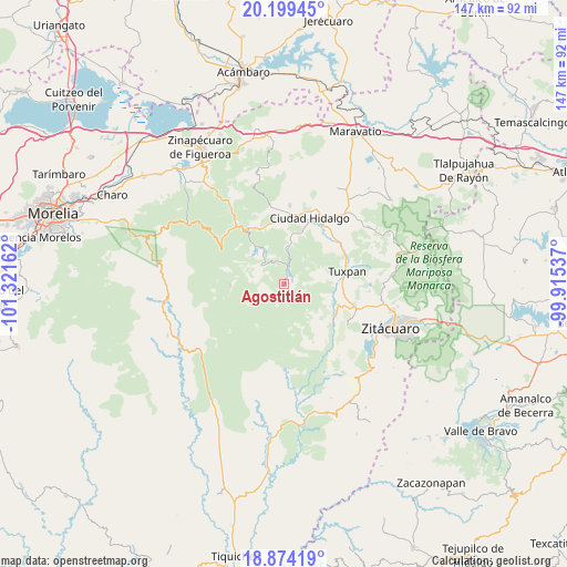
Agostitlán GPS coordinates[2]
19° 32' 17.448" North, 100° 37' 6.564" West
| Map corner | latitude | longitude |
|---|---|---|
| Upper-left | 20.19945°, | -101.32162° |
| Center: | 19.53818°, | -100.61849° |
| Lower-right: | 18.87419°, | -99.91537° |
| Map W x H: | 147.4×147.4 km | = 91.6×91.6mi |
| max Lat: | 32.7° ⇑53.3% North |
| Agostitlán: | 19.53818° |
| min Lat: | ⇓46.7% South 14.53588° |
| min Long | Agostitlán | max Long |
| -117.105° | -100.61849° | -86.73105° |
| W 29.5%⇐ | ⇒70.5% E |
Elevation
Elevation of Agostitlán is 2535 m = 8317 ft, and this is 1281.3 m = 4204 ft above average elevation for this country.
| Max E: |
3497 m = 11473 ft | 6.9% |
| Agostitlán | 2535 m 8317 ft | |
| Avg. | 1253.7 m = 4113 ft | |
Min E: |
-1 m = -3 ft | 93.1% |
See also: Mexico elevation on elevation.city.
Geographical zone
Agostitlán is located in North Torrid zone (between Equator and Tropic of Cancer). Distance of this Northern Tropic circle is 433.5 km =269.4 mi to North.| Distance of | km | miles | from Agostitlán |
|---|---|---|---|
| North Pole | 7834.6 | 4868.2 | to North |
| Arctic Circle | 5228.7 | 3249 | to North |
| Tropic Cancer | 433.5 | 269.4 | to North |
| Equator | 2172.4 | 1349.9 | to South |


Nearby cities:
15 places around Agostitlán: (largest is in red/bold)
• Cerrito Colorado
12.2 km =7.6 mi,  82°
82°
• El Caracol
14.8 km =9.2 mi,  283°
283°
• El Chaparro
9.2 km =5.7 mi,  3°
3°
• El Jazmín
15.3 km =9.5 mi,  56°
56°
• El Malacate
15 km =9.3 mi,  88°
88°
• El Porvenir
14.5 km =9 mi,  353°
353°
• José María Morelos
7.7 km =4.8 mi,  307°
307°
• La Soledad
14.3 km =8.9 mi,  97°
97°
• Las Anonas
13.2 km =8.2 mi,  116°
116°
• Lázaro Cárdenas
14.9 km =9.3 mi,  111°
111°
• Mata de Pinos
4 km =2.5 mi,  7°
7°
• Pucuato
11.4 km =7.1 mi, 306°
• Puente de Tierra
10.3 km =6.4 mi,  249°
249°
• San Antonio Villalongín
14.1 km =8.8 mi,  268°
268°
• San Bartolo Cuitareo
12.7 km =7.9 mi, 8°
Sources, notices
• [Note1] Compared only with cities in Mexico existing in our database
• [Src1] Map data: © OpenStreetMap contributors (CC-BY-SA)
• [Src2] Other city data from geonames.org with taken over terms of usage.
• [Src3] Geographical zone / Annual Mean Temperature by Robert A. Rohde @ Wikipedia
