San Antonio Villalongín geodata
San Antonio Villalongín (Michoacán) is a populated place; located in Mexico in America/Mexico_City (GMT-6) time zone. With population of 2,621 people, there are 3379 cities with bigger population in this country. Compared to other cities in Mexico, 53.4% of cities are located further ↑North; 71.5% of cities are located further →East and 82% of cities have lower elevation than San Antonio Villalongín. Note1
Current local time in San Antonio Villalongín:
08:05 AM, WednesdayDifference from your time zone: hours


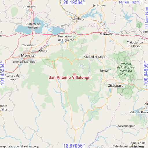
San Antonio Villalongín GPS coordinates[2]
19° 32' 4.416" North, 100° 45' 9.756" West
| Map corner | latitude | longitude |
|---|---|---|
| Upper-left | 20.19584°, | -101.45584° |
| Center: | 19.53456°, | -100.75271° |
| Lower-right: | 18.87056°, | -100.04959° |
| Map W x H: | 147.4×147.4 km | = 91.6×91.6mi |
| max Lat: | 32.7° ⇑53.4% North |
| San Antonio Villalongín: | 19.53456° |
| min Lat: | ⇓46.6% South 14.53588° |
| min Long | San Antonio Vil | max Long |
| -117.105° | -100.75271° | -86.73105° |
| W 28.5%⇐ | ⇒71.5% E |
Elevation
Elevation of San Antonio Villalongín is 2189 m = 7182 ft, and this is 935.3 m = 3069 ft above average elevation for this country.
| Max E: |
3497 m = 11473 ft | 18% |
| San Antonio Villalongín | 2189 m 7182 ft | |
| Avg. | 1253.7 m = 4113 ft | |
Min E: |
-1 m = -3 ft | 82% |
See also: Mexico elevation on elevation.city.
Geographical zone
San Antonio Villalongín is located in North Torrid zone (between Equator and Tropic of Cancer). Distance of this Northern Tropic circle is 433.9 km =269.6 mi to North.| Distance of | km | miles | from San Antonio Villalongín |
|---|---|---|---|
| North Pole | 7835 | 4868.4 | to North |
| Arctic Circle | 5229.1 | 3249.2 | to North |
| Tropic Cancer | 433.9 | 269.6 | to North |
| Equator | 2172 | 1349.6 | to South |


Nearby cities:
15 places around San Antonio Villalongín: (largest is in red/bold)
• Agostitlán
14.1 km =8.8 mi,  88°
88°
• Colonia Ecológica Asociación de Lucha Social (Lucha Social)
22.8 km =14.2 mi,  41°
41°
• El Caracol
3.9 km =2.4 mi,  355°
355°
• El Chaparro
17.5 km =10.9 mi,  56°
56°
• El Porvenir
19.3 km =12 mi, 39°
• Huajúmbaro
16.5 km =10.3 mi,  4°
4°
• José María Morelos
9.4 km =5.8 mi, 57°
• Mata de Pinos
15.2 km =9.4 mi,  73°
73°
• Pucuato
8.7 km =5.4 mi,  34°
34°
• Puente de Tierra
5.5 km =3.4 mi,  126°
126°
• San Bartolo Cuitareo
20.5 km =12.7 mi,  50°
50°
• San Lucas Huarirapeo (La Mesa de San Lucas)
20.9 km =13 mi, 40°
• San Pedro Jácuaro
23 km =14.3 mi, 29°
• Tafetán
20.8 km =12.9 mi,  231°
231°
• Tzitzio
18.9 km =11.7 mi,  287°
287°
Sources, notices
• [Note1] Compared only with cities in Mexico existing in our database
• [Src1] Map data: © OpenStreetMap contributors (CC-BY-SA)
• [Src2] Other city data from geonames.org with taken over terms of usage.
• [Src3] Geographical zone / Annual Mean Temperature by Robert A. Rohde @ Wikipedia
