El Salitre geodata
El Salitre (Aguascalientes) is a populated place; located in Mexico in America/Mexico_City (GMT-6) time zone. With population of 854 people, there are 10250 cities with bigger population in this country. Compared to other cities in Mexico, 83.1% of cities are located further ↓South; 85% of cities are located further →East and 55.6% of cities have lower elevation than El Salitre. Note1


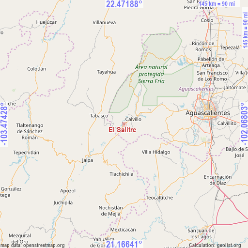
El Salitre GPS coordinates[2]
21° 49' 14.268" North, 102° 46' 16.14" West
| Map corner | latitude | longitude |
|---|---|---|
| Upper-left | 22.47188°, | -103.47428° |
| Center: | 21.82063°, | -102.77115° |
| Lower-right: | 21.16641°, | -102.06803° |
| Map W x H: | 145.2×145.2 km | = 90.2×90.2mi |
| max Lat: | 32.7° ⇑16.9% North |
| El Salitre: | 21.82063° |
| min Lat: | ⇓83.1% South 14.53588° |
| min Long | El Salitre | max Long |
| -117.105° | -102.77115° | -86.73105° |
| W 15%⇐ | ⇒85% E |
Elevation
Elevation of El Salitre is 1604 m = 5262 ft, and this is 350.3 m = 1149 ft above average elevation for this country.
| Max E: |
3497 m = 11473 ft | 44.4% |
| El Salitre | 1604 m 5262 ft | |
| Avg. | 1253.7 m = 4113 ft | |
Min E: |
-1 m = -3 ft | 55.6% |
See also: Mexico elevation on elevation.city.
Geographical zone
El Salitre is located in North Torrid zone (between Equator and Tropic of Cancer). Distance of this Northern Tropic circle is 179.7 km =111.7 mi to North.| Distance of | km | miles | from El Salitre |
|---|---|---|---|
| North Pole | 7580.8 | 4710.5 | to North |
| Arctic Circle | 4974.9 | 3091.3 | to North |
| Tropic Cancer | 179.7 | 111.7 | to North |
| Equator | 2426.2 | 1507.6 | to South |


Nearby cities:
15 places around El Salitre: (largest is in red/bold)
• Calvillo
6.1 km =3.8 mi,  62°
62°
• Crucero Las Pilas
1.3 km =0.8 mi, 56°
• El Cuervero (Cuerveros)
10 km =6.2 mi, 63°
• Jaltiche de Arriba
5.4 km =3.4 mi,  199°
199°
• La Panadera
8.9 km =5.5 mi, 57°
• La Rinconada
4.5 km =2.8 mi,  218°
218°
• Malpaso
11.8 km =7.3 mi,  68°
68°
• Mesa Grande
5.4 km =3.4 mi,  108°
108°
• Ojo de Agua
3.2 km =2 mi, 202°
• Ojocaliente
11.4 km =7.1 mi, 58°
• Presa de los Serna
7.2 km =4.5 mi,  257°
257°
• San Tadeo
13.2 km =8.2 mi,  33°
33°
• Solidaridad [Fraccionamiento]
10 km =6.2 mi,  42°
42°
• Tabasco
15.2 km =9.4 mi,  288°
288°
• Valle Huejúcar (Fraccionamiento Popular) [Fraccionamiento]
2.4 km =1.5 mi, 61°
Sources, notices
• [Note1] Compared only with cities in Mexico existing in our database
• [Src1] Map data: © OpenStreetMap contributors (CC-BY-SA)
• [Src2] Other city data from geonames.org with taken over terms of usage.
• [Src3] Geographical zone / Annual Mean Temperature by Robert A. Rohde @ Wikipedia
