Mesa Grande geodata
Mesa Grande (Aguascalientes) is a populated place; located in Mexico in America/Mexico_City (GMT-6) time zone. With population of 1,149 people, there are 7545 cities with bigger population in this country. Compared to other cities in Mexico, 83% of cities are located further ↓South; 84.9% of cities are located further →East and 62.8% of cities have lower elevation than Mesa Grande. Note1


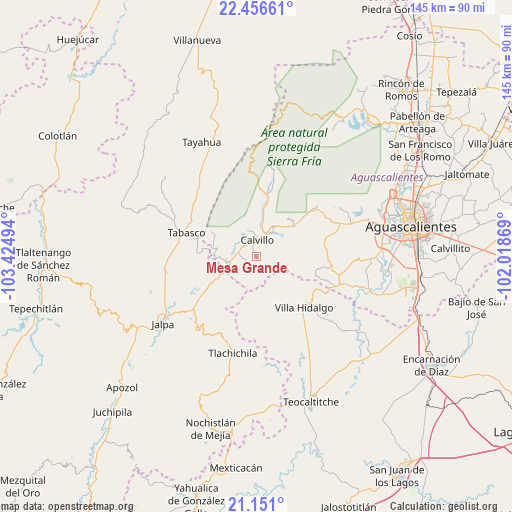
Mesa Grande GPS coordinates[2]
21° 48' 19.044" North, 102° 43' 18.516" West
| Map corner | latitude | longitude |
|---|---|---|
| Upper-left | 22.45661°, | -103.42494° |
| Center: | 21.80529°, | -102.72181° |
| Lower-right: | 21.151°, | -102.01869° |
| Map W x H: | 145.2×145.2 km | = 90.2×90.2mi |
| max Lat: | 32.7° ⇑17% North |
| Mesa Grande: | 21.80529° |
| min Lat: | ⇓83% South 14.53588° |
| min Long | Mesa Grande | max Long |
| -117.105° | -102.72181° | -86.73105° |
| W 15.1%⇐ | ⇒84.9% E |
Elevation
Elevation of Mesa Grande is 1774 m = 5820 ft, and this is 520.3 m = 1707 ft above average elevation for this country.
| Max E: |
3497 m = 11473 ft | 37.2% |
| Mesa Grande | 1774 m 5820 ft | |
| Avg. | 1253.7 m = 4113 ft | |
Min E: |
-1 m = -3 ft | 62.8% |
See also: Mexico elevation on elevation.city.
Geographical zone
Mesa Grande is located in North Torrid zone (between Equator and Tropic of Cancer). Distance of this Northern Tropic circle is 181.4 km =112.7 mi to North.| Distance of | km | miles | from Mesa Grande |
|---|---|---|---|
| North Pole | 7582.5 | 4711.5 | to North |
| Arctic Circle | 4976.7 | 3092.4 | to North |
| Tropic Cancer | 181.4 | 112.7 | to North |
| Equator | 2424.5 | 1506.5 | to South |


Nearby cities:
15 places around Mesa Grande: (largest is in red/bold)
• Calvillo
4.5 km =2.8 mi,  4°
4°
• Crucero Las Pilas
4.7 km =2.9 mi,  301°
301°
• El Cuervero (Cuerveros)
7.3 km =4.5 mi,  32°
32°
• El Salitre
5.4 km =3.4 mi,  288°
288°
• Jaltiche de Arriba
7.7 km =4.8 mi,  244°
244°
• La Labor
17.6 km =10.9 mi,  8°
8°
• La Panadera
7 km =4.3 mi,  20°
20°
• La Rinconada
8.1 km =5 mi,  257°
257°
• Malpaso
8.4 km =5.2 mi,  44°
44°
• Ojo de Agua
6.5 km =4 mi, 258°
• Ojocaliente
8.9 km =5.5 mi, 31°
• Presa de los Serna
12.2 km =7.6 mi,  270°
270°
• San Tadeo
12.9 km =8 mi, 9°
• Solidaridad [Fraccionamiento]
9.3 km =5.8 mi, 10°
• Valle Huejúcar (Fraccionamiento Popular) [Fraccionamiento]
4.1 km =2.5 mi,  314°
314°
Sources, notices
• [Note1] Compared only with cities in Mexico existing in our database
• [Src1] Map data: © OpenStreetMap contributors (CC-BY-SA)
• [Src2] Other city data from geonames.org with taken over terms of usage.
• [Src3] Geographical zone / Annual Mean Temperature by Robert A. Rohde @ Wikipedia
