Jaltomate geodata
Jaltomate (Aguascalientes) is a populated place; located in Mexico in America/Mexico_City (GMT-6) time zone. With population of 2,299 people, there are 3836 cities with bigger population in this country. Compared to other cities in Mexico, 84.3% of cities are located further ↓South; 81.8% of cities are located further →East and 70.2% of cities have lower elevation than Jaltomate. Note1


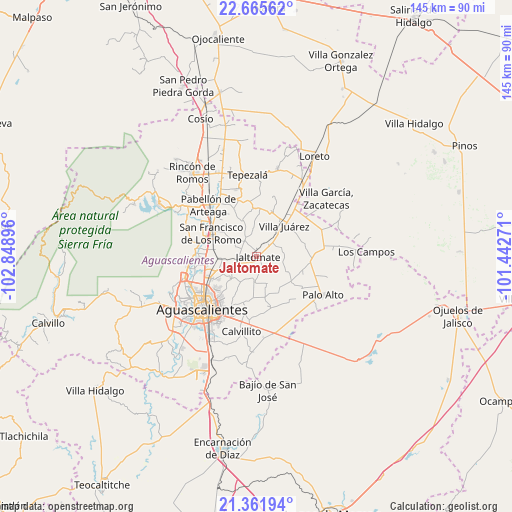
Jaltomate GPS coordinates[2]
22° 0' 55.008" North, 102° 8' 44.988" West
| Map corner | latitude | longitude |
|---|---|---|
| Upper-left | 22.66562°, | -102.84896° |
| Center: | 22.01528°, | -102.14583° |
| Lower-right: | 21.36194°, | -101.44271° |
| Map W x H: | 145×145 km | = 90.1×90.1mi |
| max Lat: | 32.7° ⇑15.7% North |
| Jaltomate: | 22.01528° |
| min Lat: | ⇓84.3% South 14.53588° |
| min Long | Jaltomate | max Long |
| -117.105° | -102.14583° | -86.73105° |
| W 18.2%⇐ | ⇒81.8% E |
Elevation
Elevation of Jaltomate is 1929 m = 6329 ft, and this is 675.3 m = 2216 ft above average elevation for this country.
| Max E: |
3497 m = 11473 ft | 29.8% |
| Jaltomate | 1929 m 6329 ft | |
| Avg. | 1253.7 m = 4113 ft | |
Min E: |
-1 m = -3 ft | 70.2% |
See also: Mexico elevation on elevation.city.
Geographical zone
Jaltomate is located in North Torrid zone (between Equator and Tropic of Cancer). Distance of this Northern Tropic circle is 158 km =98.2 mi to North.| Distance of | km | miles | from Jaltomate |
|---|---|---|---|
| North Pole | 7559.2 | 4697.1 | to North |
| Arctic Circle | 4953.3 | 3077.8 | to North |
| Tropic Cancer | 158 | 98.2 | to North |
| Equator | 2447.9 | 1521.1 | to South |


Nearby cities:
15 places around Jaltomate: (largest is in red/bold)
• Cañada Honda
5.4 km =3.4 mi,  259°
259°
• Chicalote
11 km =6.8 mi,  267°
267°
• Conejal
12.6 km =7.8 mi,  210°
210°
• El Tule
9.5 km =5.9 mi,  36°
36°
• Jilotepec
7.4 km =4.6 mi,  70°
70°
• La Dichosa
4.6 km =2.9 mi,  51°
51°
• La Escondida
11.9 km =7.4 mi,  281°
281°
• Licenciado Jesús Terán (El Muerto)
9.4 km =5.8 mi,  115°
115°
• Loretito (Charco del Toro)
10.2 km =6.3 mi, 261°
• Macario J. Gómez [Colonia]
11.5 km =7.1 mi,  250°
250°
• Paseos de la Providencia [Fraccionamiento]
13.6 km =8.5 mi, 274°
• Santa María Gallardo
4.9 km =3 mi, 40°
• Valle de Aguascalientes
13.1 km =8.1 mi, 249°
• Villa Juárez
11.8 km =7.3 mi, 41°
• Viudas de Poniente
11.6 km =7.2 mi,  32°
32°
Sources, notices
• [Note1] Compared only with cities in Mexico existing in our database
• [Src1] Map data: © OpenStreetMap contributors (CC-BY-SA)
• [Src2] Other city data from geonames.org with taken over terms of usage.
• [Src3] Geographical zone / Annual Mean Temperature by Robert A. Rohde @ Wikipedia
