La Dichosa geodata
La Dichosa (Aguascalientes) is a populated place; located in Mexico in America/Mexico_City (GMT-6) time zone. With population of 961 people, there are 9056 cities with bigger population in this country. Compared to other cities in Mexico, 84.5% of cities are located further ↓South; 81.6% of cities are located further →East and 71.1% of cities have lower elevation than La Dichosa. Note1


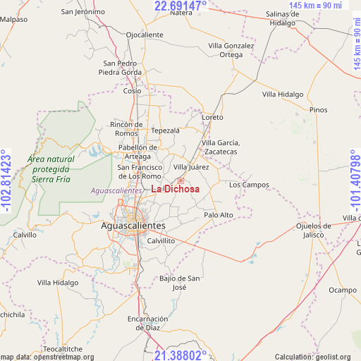
La Dichosa GPS coordinates[2]
22° 2' 28.5" North, 102° 6' 39.96" West
| Map corner | latitude | longitude |
|---|---|---|
| Upper-left | 22.69147°, | -102.81423° |
| Center: | 22.04125°, | -102.1111° |
| Lower-right: | 21.38802°, | -101.40798° |
| Map W x H: | 144.9×144.9 km | = 90×90mi |
| max Lat: | 32.7° ⇑15.5% North |
| La Dichosa: | 22.04125° |
| min Lat: | ⇓84.5% South 14.53588° |
| min Long | La Dichosa | max Long |
| -117.105° | -102.1111° | -86.73105° |
| W 18.4%⇐ | ⇒81.6% E |
Elevation
Elevation of La Dichosa is 1947 m = 6388 ft, and this is 693.3 m = 2275 ft above average elevation for this country.
| Max E: |
3497 m = 11473 ft | 28.9% |
| La Dichosa | 1947 m 6388 ft | |
| Avg. | 1253.7 m = 4113 ft | |
Min E: |
-1 m = -3 ft | 71.1% |
See also: Mexico elevation on elevation.city.
Geographical zone
La Dichosa is located in North Torrid zone (between Equator and Tropic of Cancer). Distance of this Northern Tropic circle is 155.2 km =96.4 mi to North.| Distance of | km | miles | from La Dichosa |
|---|---|---|---|
| North Pole | 7556.3 | 4695.3 | to North |
| Arctic Circle | 4950.4 | 3076 | to North |
| Tropic Cancer | 155.2 | 96.4 | to North |
| Equator | 2450.8 | 1522.9 | to South |


Nearby cities:
15 places around La Dichosa: (largest is in red/bold)
• Cañada Honda
9.7 km =6 mi,  246°
246°
• Clavellinas
11.3 km =7 mi,  346°
346°
• El Novillo
11.6 km =7.2 mi,  101°
101°
• El Polvo
10.3 km =6.4 mi,  1°
1°
• El Tule
5.2 km =3.2 mi,  23°
23°
• Francisco Sarabia (La Reforma)
12.4 km =7.7 mi,  130°
130°
• Jaltomate
4.6 km =2.9 mi,  231°
231°
• Jilotepec
3.4 km =2.1 mi, 97°
• La Luz
12.7 km =7.9 mi,  110°
110°
• Licenciado Jesús Terán (El Muerto)
8.5 km =5.3 mi,  145°
145°
• Molinos
13.6 km =8.5 mi,  7°
7°
• San José del Río
10.5 km =6.5 mi,  29°
29°
• Santa María Gallardo
0.9 km =0.6 mi,  331°
331°
• Villa Juárez
7.3 km =4.5 mi,  36°
36°
• Viudas de Poniente
7.4 km =4.6 mi, 21°
Sources, notices
• [Note1] Compared only with cities in Mexico existing in our database
• [Src1] Map data: © OpenStreetMap contributors (CC-BY-SA)
• [Src2] Other city data from geonames.org with taken over terms of usage.
• [Src3] Geographical zone / Annual Mean Temperature by Robert A. Rohde @ Wikipedia
