El Tule geodata
El Tule (Aguascalientes) is a populated place; located in Mexico in America/Mexico_City (GMT-6) time zone. With population of 1,189 people, there are 7304 cities with bigger population in this country. Compared to other cities in Mexico, 84.6% of cities are located further ↓South; 81.5% of cities are located further →East and 72.3% of cities have lower elevation than El Tule. Note1


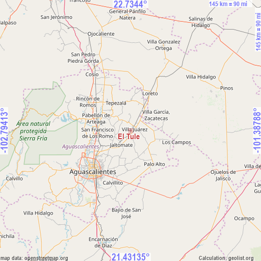
El Tule GPS coordinates[2]
22° 5' 3.768" North, 102° 5' 27.6" West
| Map corner | latitude | longitude |
|---|---|---|
| Upper-left | 22.7344°, | -102.79413° |
| Center: | 22.08438°, | -102.091° |
| Lower-right: | 21.43135°, | -101.38788° |
| Map W x H: | 144.9×144.9 km | = 90×90mi |
| max Lat: | 32.7° ⇑15.4% North |
| El Tule: | 22.08438° |
| min Lat: | ⇓84.6% South 14.53588° |
| min Long | El Tule | max Long |
| -117.105° | -102.091° | -86.73105° |
| W 18.5%⇐ | ⇒81.5% E |
Elevation
Elevation of El Tule is 1974 m = 6476 ft, and this is 720.3 m = 2363 ft above average elevation for this country.
| Max E: |
3497 m = 11473 ft | 27.7% |
| El Tule | 1974 m 6476 ft | |
| Avg. | 1253.7 m = 4113 ft | |
Min E: |
-1 m = -3 ft | 72.3% |
See also: Mexico elevation on elevation.city.
Geographical zone
El Tule is located in North Torrid zone (between Equator and Tropic of Cancer). Distance of this Northern Tropic circle is 150.4 km =93.5 mi to North.| Distance of | km | miles | from El Tule |
|---|---|---|---|
| North Pole | 7551.5 | 4692.3 | to North |
| Arctic Circle | 4945.6 | 3073.1 | to North |
| Tropic Cancer | 150.4 | 93.5 | to North |
| Equator | 2455.6 | 1525.8 | to South |


Nearby cities:
15 places around El Tule: (largest is in red/bold)
• Clavellinas
7.8 km =4.8 mi,  322°
322°
• El Copetillo
11.3 km =7 mi,  54°
54°
• El Novillo
11.7 km =7.3 mi,  127°
127°
• El Polvo
5.8 km =3.6 mi,  342°
342°
• El Tepozán
10.9 km =6.8 mi,  330°
330°
• Jaltomate
9.5 km =5.9 mi,  216°
216°
• Jilotepec
5.4 km =3.4 mi,  165°
165°
• La Dichosa
5.2 km =3.2 mi,  203°
203°
• Lázaro Cárdenas
11.7 km =7.3 mi,  34°
34°
• Molinos
8.7 km =5.4 mi,  357°
357°
• Pino Suárez
9 km =5.6 mi,  350°
350°
• San José del Río
5.3 km =3.3 mi, 34°
• Santa María Gallardo
4.7 km =2.9 mi,  212°
212°
• Villa Juárez
2.5 km =1.6 mi,  63°
63°
• Viudas de Poniente
2.2 km =1.4 mi,  15°
15°
Sources, notices
• [Note1] Compared only with cities in Mexico existing in our database
• [Src1] Map data: © OpenStreetMap contributors (CC-BY-SA)
• [Src2] Other city data from geonames.org with taken over terms of usage.
• [Src3] Geographical zone / Annual Mean Temperature by Robert A. Rohde @ Wikipedia
