Los Adobes geodata
Los Adobes (Nuevo León) is a populated place; located in Mexico in America/Monterrey (GMT-6) time zone. With population of 514 people, there are 16370 cities with bigger population in this country. Compared to other cities in Mexico, 91.8% of cities are located further ↓South; 69.8% of cities are located further →East and 67.8% of cities have lower elevation than Los Adobes. Note1


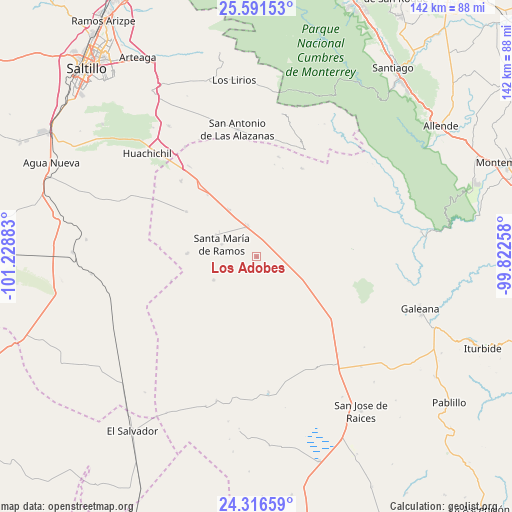
Los Adobes GPS coordinates[2]
24° 57' 20.556" North, 100° 31' 32.52" West
| Map corner | latitude | longitude |
|---|---|---|
| Upper-left | 25.59153°, | -101.22883° |
| Center: | 24.95571°, | -100.5257° |
| Lower-right: | 24.31659°, | -99.82258° |
| Map W x H: | 141.8×141.8 km | = 88.1×88.1mi |
| max Lat: | 32.7° ⇑8.2% North |
| Los Adobes: | 24.95571° |
| min Lat: | ⇓91.8% South 14.53588° |
| min Long | Los Adobes | max Long |
| -117.105° | -100.5257° | -86.73105° |
| W 30.2%⇐ | ⇒69.8% E |
Elevation
Elevation of Los Adobes is 1886 m = 6188 ft, and this is 632.3 m = 2074 ft above average elevation for this country.
| Max E: |
3497 m = 11473 ft | 32.2% |
| Los Adobes | 1886 m 6188 ft | |
| Avg. | 1253.7 m = 4113 ft | |
Min E: |
-1 m = -3 ft | 67.8% |
See also: Mexico elevation on elevation.city.
Geographical zone
Los Adobes is located in North temperate zone (between Tropic of Cancer and the Arctic Circle). Distance of this Northern Tropic circle is 168.9 km =104.9 mi to South.| Distance of | km | miles | from Los Adobes |
|---|---|---|---|
| North Pole | 7232.2 | 4493.9 | to North |
| Arctic Circle | 4626.4 | 2874.7 | to North |
| Tropic Cancer | 168.9 | 104.9 | to South |
| Equator | 2774.8 | 1724.2 | to South |


Nearby cities:
15 places around Los Adobes: (largest is in red/bold)
• Aquiles Serdán (La Hediondilla)
19.1 km =11.9 mi,  271°
271°
• Catarino Rodríguez
24.1 km =15 mi,  120°
120°
• El Salvador
59.3 km =36.8 mi,  215°
215°
• El Tunal
52.9 km =32.9 mi,  348°
348°
• Galeana
47.6 km =29.6 mi,  107°
107°
• Huachichil
41.5 km =25.8 mi,  313°
313°
• Laguna de Labradores
44 km =27.3 mi, 110°
• Las Delicias
13.6 km =8.5 mi,  241°
241°
• Los Lirios
49.1 km =30.5 mi, 352°
• Navidad
14.9 km =9.3 mi,  329°
329°
• Puerto México
31.2 km =19.4 mi,  323°
323°
• Rayones
46.1 km =28.6 mi,  81°
81°
• San Antonio de las Alazanas
35.5 km =22.1 mi, 351°
• San José de Raíces
51.6 km =32.1 mi,  145°
145°
• San Rafael
8.7 km =5.4 mi,  342°
342°
Sources, notices
• [Note1] Compared only with cities in Mexico existing in our database
• [Src1] Map data: © OpenStreetMap contributors (CC-BY-SA)
• [Src2] Other city data from geonames.org with taken over terms of usage.
• [Src3] Geographical zone / Annual Mean Temperature by Robert A. Rohde @ Wikipedia
