Huachichil geodata
Huachichil (Coahuila) is a populated place; located in Mexico in America/Monterrey (GMT-6) time zone. With population of 1,616 people, there are 5361 cities with bigger population in this country. Compared to other cities in Mexico, 92% of cities are located further ↓South; 72.1% of cities are located further →East and 78.4% of cities have lower elevation than Huachichil. Note1


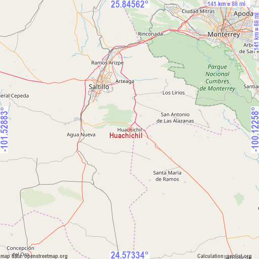
Huachichil GPS coordinates[2]
25° 12' 40.104" North, 100° 49' 32.52" West
| Map corner | latitude | longitude |
|---|---|---|
| Upper-left | 25.84562°, | -101.52883° |
| Center: | 25.21114°, | -100.8257° |
| Lower-right: | 24.57334°, | -100.12258° |
| Map W x H: | 141.5×141.5 km | = 87.9×87.9mi |
| max Lat: | 32.7° ⇑8% North |
| Huachichil: | 25.21114° |
| min Lat: | ⇓92% South 14.53588° |
| min Long | Huachichil | max Long |
| -117.105° | -100.8257° | -86.73105° |
| W 27.9%⇐ | ⇒72.1% E |
Elevation
Elevation of Huachichil is 2097 m = 6880 ft, and this is 843.3 m = 2767 ft above average elevation for this country.
| Max E: |
3497 m = 11473 ft | 21.6% |
| Huachichil | 2097 m 6880 ft | |
| Avg. | 1253.7 m = 4113 ft | |
Min E: |
-1 m = -3 ft | 78.4% |
See also: Mexico elevation on elevation.city.
Geographical zone
Huachichil is located in North temperate zone (between Tropic of Cancer and the Arctic Circle). Distance of this Northern Tropic circle is 197.3 km =122.6 mi to South.| Distance of | km | miles | from Huachichil |
|---|---|---|---|
| North Pole | 7203.8 | 4476.2 | to North |
| Arctic Circle | 4598 | 2857.1 | to North |
| Tropic Cancer | 197.3 | 122.6 | to South |
| Equator | 2803.2 | 1741.8 | to South |


Nearby cities:
15 places around Huachichil: (largest is in red/bold)
• Agua Nueva
26.5 km =16.5 mi,  264°
264°
• Aquiles Serdán (La Hediondilla)
30 km =18.6 mi,  158°
158°
• Arteaga
26.1 km =16.2 mi,  355°
355°
• Cuatro de Octubre
27 km =16.8 mi,  345°
345°
• El Tunal
30.3 km =18.8 mi,  39°
39°
• Las Delicias
39.4 km =24.5 mi,  152°
152°
• Los Adobes
41.5 km =25.8 mi,  133°
133°
• Los Lirios
31.4 km =19.5 mi,  49°
49°
• Navidad
27.4 km =17 mi,  124°
124°
• Puerto México
12 km =7.5 mi,  106°
106°
• Ramos Arizpe
38.5 km =23.9 mi,  341°
341°
• Saltillo
29.7 km =18.5 mi,  322°
322°
• San Antonio de las Alazanas
25.8 km =16 mi,  74°
74°
• San Juan de la Vaquería
39.9 km =24.8 mi,  276°
276°
• San Rafael
34.1 km =21.2 mi, 126°
Sources, notices
• [Note1] Compared only with cities in Mexico existing in our database
• [Src1] Map data: © OpenStreetMap contributors (CC-BY-SA)
• [Src2] Other city data from geonames.org with taken over terms of usage.
• [Src3] Geographical zone / Annual Mean Temperature by Robert A. Rohde @ Wikipedia
