Galeana geodata
Galeana (Nuevo León) is a seat of a second-order administrative division; located in Mexico in America/Monterrey (GMT-6) time zone. With population of 7,024 people, there are 1324 cities with bigger population in this country. Compared to other cities in Mexico, 91.6% of cities are located further ↓South; 64.9% of cities are located further →East and 56.3% of cities have lower elevation than Galeana. Note1


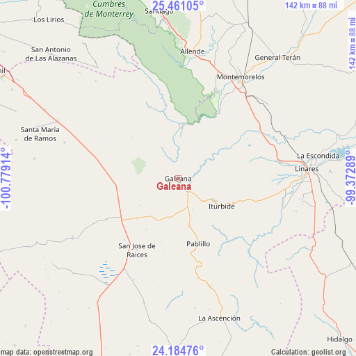
Galeana GPS coordinates[2]
24° 49' 28.38" North, 100° 4' 33.636" West
| Map corner | latitude | longitude |
|---|---|---|
| Upper-left | 25.46105°, | -100.77914° |
| Center: | 24.82455°, | -100.07601° |
| Lower-right: | 24.18476°, | -99.37289° |
| Map W x H: | 141.9×141.9 km | = 88.2×88.2mi |
| max Lat: | 32.7° ⇑8.4% North |
| Galeana: | 24.82455° |
| min Lat: | ⇓91.6% South 14.53588° |
| min Long | Galeana | max Long |
| -117.105° | -100.07601° | -86.73105° |
| W 35.1%⇐ | ⇒64.9% E |
Elevation
Elevation of Galeana is 1631 m = 5351 ft, and this is 377.3 m = 1238 ft above average elevation for this country.
| Max E: |
3497 m = 11473 ft | 43.7% |
| Galeana | 1631 m 5351 ft | |
| Avg. | 1253.7 m = 4113 ft | |
Min E: |
-1 m = -3 ft | 56.3% |
See also: Mexico elevation on elevation.city.
Geographical zone
Galeana is located in North temperate zone (between Tropic of Cancer and the Arctic Circle). Distance of this Northern Tropic circle is 154.3 km =95.9 mi to South.| Distance of | km | miles | from Galeana |
|---|---|---|---|
| North Pole | 7246.8 | 4503 | to North |
| Arctic Circle | 4640.9 | 2883.7 | to North |
| Tropic Cancer | 154.3 | 95.9 | to South |
| Equator | 2760.2 | 1715.1 | to South |


Nearby cities:
15 places around Galeana: (largest is in red/bold)
• Catarino Rodríguez
24.8 km =15.4 mi,  275°
275°
• Ciudad de Allende
50.7 km =31.5 mi,  7°
7°
• Congregación Calles
46.8 km =29.1 mi,  17°
17°
• Hualahuises
41 km =25.5 mi,  80°
80°
• Iturbide
20.5 km =12.7 mi,  122°
122°
• Laguna de Labradores
4.2 km =2.6 mi,  258°
258°
• Linares
51.4 km =31.9 mi,  85°
85°
• Los Adobes
47.6 km =29.6 mi,  287°
287°
• Mazatlan
47.6 km =29.6 mi,  31°
31°
• Pablillo
27.1 km =16.8 mi,  162°
162°
• Paso Hondo
51.9 km =32.2 mi, 12°
• Rayones
21.5 km =13.4 mi,  0°
0°
• Río Verde
54.4 km =33.8 mi, 81°
• San José de Raíces
32.7 km =20.3 mi,  210°
210°
• San Rafael
53.1 km =33 mi,  295°
295°
Sources, notices
• [Note1] Compared only with cities in Mexico existing in our database
• [Src1] Map data: © OpenStreetMap contributors (CC-BY-SA)
• [Src2] Other city data from geonames.org with taken over terms of usage.
• [Src3] Geographical zone / Annual Mean Temperature by Robert A. Rohde @ Wikipedia
