Tuna Mansa geodata
Tuna Mansa (Guanajuato) is a populated place; located in Mexico in America/Mexico_City (GMT-6) time zone. With population of 769 people, there are 11375 cities with bigger population in this country. Compared to other cities in Mexico, 76.9% of cities are located further ↓South; 76.5% of cities are located further →East and 70.1% of cities have lower elevation than Tuna Mansa. Note1


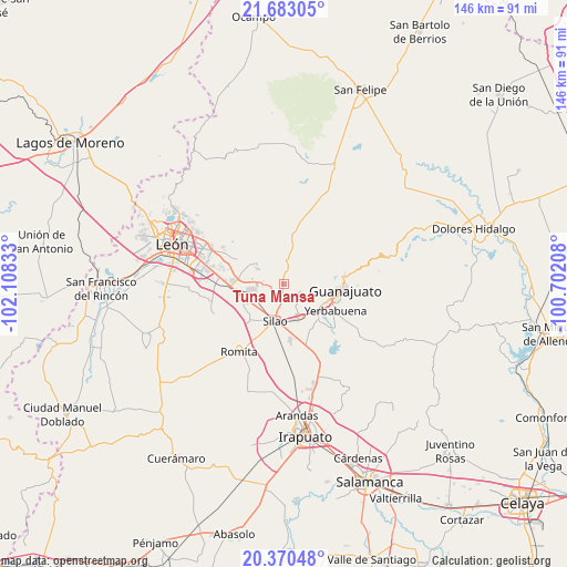
Tuna Mansa GPS coordinates[2]
21° 1' 41.556" North, 101° 24' 18.72" West
| Map corner | latitude | longitude |
|---|---|---|
| Upper-left | 21.68305°, | -102.10833° |
| Center: | 21.02821°, | -101.4052° |
| Lower-right: | 20.37048°, | -100.70208° |
| Map W x H: | 145.9×145.9 km | = 90.7×90.7mi |
| max Lat: | 32.7° ⇑23.1% North |
| Tuna Mansa: | 21.02821° |
| min Lat: | ⇓76.9% South 14.53588° |
| min Long | Tuna Mansa | max Long |
| -117.105° | -101.4052° | -86.73105° |
| W 23.5%⇐ | ⇒76.5% E |
Elevation
Elevation of Tuna Mansa is 1925 m = 6316 ft, and this is 671.3 m = 2202 ft above average elevation for this country.
| Max E: |
3497 m = 11473 ft | 29.9% |
| Tuna Mansa | 1925 m 6316 ft | |
| Avg. | 1253.7 m = 4113 ft | |
Min E: |
-1 m = -3 ft | 70.1% |
See also: Mexico elevation on elevation.city.
Geographical zone
Tuna Mansa is located in North Torrid zone (between Equator and Tropic of Cancer). Distance of this Northern Tropic circle is 267.8 km =166.4 mi to North.| Distance of | km | miles | from Tuna Mansa |
|---|---|---|---|
| North Pole | 7668.9 | 4765.2 | to North |
| Arctic Circle | 5063.1 | 3146.1 | to North |
| Tropic Cancer | 267.8 | 166.4 | to North |
| Equator | 2338.1 | 1452.8 | to South |


Nearby cities:
15 places around Tuna Mansa: (largest is in red/bold)
• Aguas Buenas
7.3 km =4.5 mi,  152°
152°
• Chichimequillas
4 km =2.5 mi,  284°
284°
• Colonia Francisco Javier Mina
5.5 km =3.4 mi,  192°
192°
• El Coecillo
7.4 km =4.6 mi,  219°
219°
• El Paraíso
1.6 km =1 mi,  93°
93°
• Loma de Yerbabuena
5.8 km =3.6 mi,  308°
308°
• Los Lorenzos
5.8 km =3.6 mi,  31°
31°
• Monte del Coecillo
6.3 km =3.9 mi,  209°
209°
• Pabileros
4.5 km =2.8 mi,  170°
170°
• Paxtle
3.4 km =2.1 mi,  2°
2°
• Providencia de Nápoles
5.5 km =3.4 mi,  263°
263°
• Rancho Seco
4.3 km =2.7 mi,  195°
195°
• Salitrillo
5.4 km =3.4 mi, 279°
• San Agustín de las Flores
4 km =2.5 mi,  234°
234°
• Velarde
3.3 km =2.1 mi, 167°
Sources, notices
• [Note1] Compared only with cities in Mexico existing in our database
• [Src1] Map data: © OpenStreetMap contributors (CC-BY-SA)
• [Src2] Other city data from geonames.org with taken over terms of usage.
• [Src3] Geographical zone / Annual Mean Temperature by Robert A. Rohde @ Wikipedia
