Velarde geodata
Velarde (Guanajuato) is a populated place; located in Mexico in America/Mexico_City (GMT-6) time zone. With population of 521 people, there are 16186 cities with bigger population in this country. Compared to other cities in Mexico, 76.4% of cities are located further ↓South; 76.4% of cities are located further →East and 70.8% of cities have lower elevation than Velarde. Note1


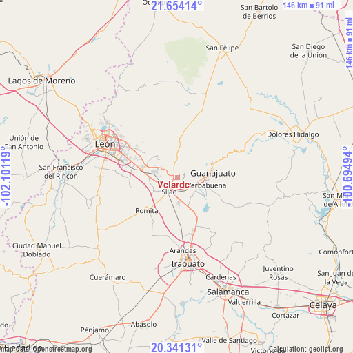
Velarde GPS coordinates[2]
20° 59' 57.012" North, 101° 23' 53.016" West
| Map corner | latitude | longitude |
|---|---|---|
| Upper-left | 21.65414°, | -102.10119° |
| Center: | 20.99917°, | -101.39806° |
| Lower-right: | 20.34131°, | -100.69494° |
| Map W x H: | 146×146 km | = 90.7×90.7mi |
| max Lat: | 32.7° ⇑23.6% North |
| Velarde: | 20.99917° |
| min Lat: | ⇓76.4% South 14.53588° |
| min Long | Velarde | max Long |
| -117.105° | -101.39806° | -86.73105° |
| W 23.6%⇐ | ⇒76.4% E |
Elevation
Elevation of Velarde is 1940 m = 6365 ft, and this is 686.3 m = 2252 ft above average elevation for this country.
| Max E: |
3497 m = 11473 ft | 29.2% |
| Velarde | 1940 m 6365 ft | |
| Avg. | 1253.7 m = 4113 ft | |
Min E: |
-1 m = -3 ft | 70.8% |
See also: Mexico elevation on elevation.city.
Geographical zone
Velarde is located in North Torrid zone (between Equator and Tropic of Cancer). Distance of this Northern Tropic circle is 271 km =168.4 mi to North.| Distance of | km | miles | from Velarde |
|---|---|---|---|
| North Pole | 7672.2 | 4767.3 | to North |
| Arctic Circle | 5066.3 | 3148.1 | to North |
| Tropic Cancer | 271 | 168.4 | to North |
| Equator | 2334.9 | 1450.8 | to South |


Nearby cities:
15 places around Velarde: (largest is in red/bold)
• Aguas Buenas
4.2 km =2.6 mi,  140°
140°
• Cerritos
6.7 km =4.2 mi,  184°
184°
• Chichimequillas
6.3 km =3.9 mi,  312°
312°
• Colonia Emiliano Zapata (El Cerrito)
6.5 km =4 mi,  255°
255°
• Colonia Francisco Javier Mina
2.9 km =1.8 mi,  220°
220°
• El Coecillo
6 km =3.7 mi,  244°
244°
• El Paraíso
3.2 km =2 mi,  15°
15°
• Monte del Coecillo
4.5 km =2.8 mi, 239°
• Pabileros
1.2 km =0.7 mi, 178°
• Paxtle
6.7 km =4.2 mi,  354°
354°
• Providencia de Nápoles
6.7 km =4.2 mi,  293°
293°
• Rancho Seco
2.1 km =1.3 mi, 243°
• San Agustín de las Flores
4.2 km =2.6 mi,  282°
282°
• Tuna Mansa
3.3 km =2.1 mi, 347°
• Villas de Guadalupe
5.6 km =3.5 mi,  186°
186°
Sources, notices
• [Note1] Compared only with cities in Mexico existing in our database
• [Src1] Map data: © OpenStreetMap contributors (CC-BY-SA)
• [Src2] Other city data from geonames.org with taken over terms of usage.
• [Src3] Geographical zone / Annual Mean Temperature by Robert A. Rohde @ Wikipedia
