Fábrica de Melchor geodata
Fábrica de Melchor (Guanajuato) is a populated place; located in Mexico in America/Mexico_City (GMT-6) time zone. With population of 1,777 people, there are 4887 cities with bigger population in this country. Compared to other cities in Mexico, 82.3% of cities are located further ↓South; 72.7% of cities are located further →East and 70.9% of cities have lower elevation than Fábrica de Melchor. Note1


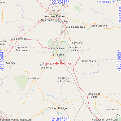
Fábrica de Melchor GPS coordinates[2]
21° 40' 20.028" North, 100° 54' 6.156" West
| Map corner | latitude | longitude |
|---|---|---|
| Upper-left | 22.32416°, | -101.60484° |
| Center: | 21.67223°, | -100.90171° |
| Lower-right: | 21.01734°, | -100.19859° |
| Map W x H: | 145.3×145.3 km | = 90.3×90.3mi |
| max Lat: | 32.7° ⇑17.7% North |
| Fábrica de Melchor: | 21.67223° |
| min Lat: | ⇓82.3% South 14.53588° |
| min Long | Fábrica de Mel | max Long |
| -117.105° | -100.90171° | -86.73105° |
| W 27.3%⇐ | ⇒72.7% E |
Elevation
Elevation of Fábrica de Melchor is 1942 m = 6371 ft, and this is 688.3 m = 2258 ft above average elevation for this country.
| Max E: |
3497 m = 11473 ft | 29.1% |
| Fábrica de Melchor | 1942 m 6371 ft | |
| Avg. | 1253.7 m = 4113 ft | |
Min E: |
-1 m = -3 ft | 70.9% |
See also: Mexico elevation on elevation.city.
Geographical zone
Fábrica de Melchor is located in North Torrid zone (between Equator and Tropic of Cancer). Distance of this Northern Tropic circle is 196.2 km =121.9 mi to North.| Distance of | km | miles | from Fábrica de Melchor |
|---|---|---|---|
| North Pole | 7597.3 | 4720.7 | to North |
| Arctic Circle | 4991.4 | 3101.5 | to North |
| Tropic Cancer | 196.2 | 121.9 | to North |
| Equator | 2409.7 | 1497.3 | to South |


Nearby cities:
15 places around Fábrica de Melchor: (largest is in red/bold)
• Alberto Carrera Torres
15.9 km =9.9 mi,  314°
314°
• Ejido la Pitahaya (Santo Domingo)
16.3 km =10.1 mi,  116°
116°
• El Carretón
9.4 km =5.8 mi,  240°
240°
• El Centenario
12.2 km =7.6 mi,  338°
338°
• El Rosario
7.3 km =4.5 mi, 339°
• El Tejocote (El Domingo)
1.4 km =0.9 mi,  287°
287°
• Emiliano Zapata
7.5 km =4.7 mi,  233°
233°
• Estancia de Atotonilco
14.2 km =8.8 mi,  111°
111°
• Guadalupe
9.2 km =5.7 mi,  302°
302°
• Guadiana
16.4 km =10.2 mi,  320°
320°
• San Francisco
16.8 km =10.4 mi,  255°
255°
• San José de Rancho Nuevo (Los Arrieros)
13.5 km =8.4 mi, 231°
• San Miguel
10.6 km =6.6 mi,  333°
333°
• Villa de Reyes
14.9 km =9.3 mi,  347°
347°
• Yerbabuena
14 km =8.7 mi,  83°
83°
Sources, notices
• [Note1] Compared only with cities in Mexico existing in our database
• [Src1] Map data: © OpenStreetMap contributors (CC-BY-SA)
• [Src2] Other city data from geonames.org with taken over terms of usage.
• [Src3] Geographical zone / Annual Mean Temperature by Robert A. Rohde @ Wikipedia
