Peñuelas geodata
Peñuelas (Guanajuato) is a populated place; located in Mexico in America/Mexico_City (GMT-6) time zone. With population of 1,438 people, there are 6005 cities with bigger population in this country. Compared to other cities in Mexico, 72% of cities are located further ↓South; 75.6% of cities are located further →East and 61% of cities have lower elevation than Peñuelas. Note1


Peñuelas GPS coordinates[2]
20° 43' 0.336" North, 101° 17' 50.964" West
| Map corner | latitude | longitude |
|---|---|---|
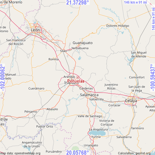
| Upper-left | 21.37298°, | -102.00062° |
| Center: | 20.71676°, | -101.29749° |
| Lower-right: | 20.05768°, | -100.59437° |
| Map W x H: | 146.2×146.2 km | = 90.8×90.8mi |
| max Lat: | 32.7° ⇑28% North |
| Peñuelas: | 20.71676° |
| min Lat: | ⇓72% South 14.53588° |
| min Long | Peñuelas | max Long |
| -117.105° | -101.29749° | -86.73105° |
| W 24.4%⇐ | ⇒75.6% E |
Elevation
Elevation of Peñuelas is 1744 m = 5722 ft, and this is 490.3 m = 1609 ft above average elevation for this country.
| Max E: |
3497 m = 11473 ft | 39% |
| Peñuelas | 1744 m 5722 ft | |
| Avg. | 1253.7 m = 4113 ft | |
Min E: |
-1 m = -3 ft | 61% |
See also: Mexico elevation on elevation.city.
Geographical zone
Peñuelas is located in North Torrid zone (between Equator and Tropic of Cancer). Distance of this Northern Tropic circle is 302.4 km =187.9 mi to North.| Distance of | km | miles | from Peñuelas |
|---|---|---|---|
| North Pole | 7703.6 | 4786.8 | to North |
| Arctic Circle | 5097.7 | 3167.6 | to North |
| Tropic Cancer | 302.4 | 187.9 | to North |
| Equator | 2303.5 | 1431.3 | to South |


Nearby cities:
15 places around Peñuelas: (largest is in red/bold)
• Arandas
7.9 km =4.9 mi,  276°
276°
• Carrizal Grande
1.5 km =0.9 mi,  217°
217°
• El Carrizalito
3.2 km =2 mi,  242°
242°
• El Copalillo
5.2 km =3.2 mi, 283°
• Ex-Hacienda del Copal
4.8 km =3 mi,  304°
304°
• Fraccionamiento Campestre las Flores
5.2 km =3.2 mi, 281°
• Irapuato
7.6 km =4.7 mi,  233°
233°
• La Garrida
7.5 km =4.7 mi, 298°
• Lo de Juárez
7.3 km =4.5 mi,  321°
321°
• Nueva Colonia Copalillo (El Atorón)
9 km =5.6 mi, 295°
• San José Temascatío
4.8 km =3 mi,  125°
125°
• San Nicolás Temascatío
5.1 km =3.2 mi,  79°
79°
• Santa Rosa Temascatío (Santa Rosa de la Cruz)
8.1 km =5 mi,  33°
33°
• Taretán
7.9 km =4.9 mi,  330°
330°
• Valencianita
3.4 km =2.1 mi,  351°
351°
Sources, notices
• [Note1] Compared only with cities in Mexico existing in our database
• [Src1] Map data: © OpenStreetMap contributors (CC-BY-SA)
• [Src2] Other city data from geonames.org with taken over terms of usage.
• [Src3] Geographical zone / Annual Mean Temperature by Robert A. Rohde @ Wikipedia
