Taretán geodata
Taretán (Guanajuato) is a populated place; located in Mexico in America/Mexico_City (GMT-6) time zone. With population of 1,123 people, there are 7722 cities with bigger population in this country. Compared to other cities in Mexico, 73% of cities are located further ↓South; 75.9% of cities are located further →East and 62.4% of cities have lower elevation than Taretán. Note1


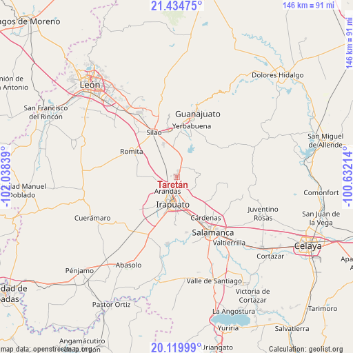
Taretán GPS coordinates[2]
20° 46' 43.68" North, 101° 20' 6.936" West
| Map corner | latitude | longitude |
|---|---|---|
| Upper-left | 21.43475°, | -102.03839° |
| Center: | 20.7788°, | -101.33526° |
| Lower-right: | 20.11999°, | -100.63214° |
| Map W x H: | 146.2×146.2 km | = 90.8×90.8mi |
| max Lat: | 32.7° ⇑27% North |
| Taretán: | 20.7788° |
| min Lat: | ⇓73% South 14.53588° |
| min Long | Taretán | max Long |
| -117.105° | -101.33526° | -86.73105° |
| W 24.1%⇐ | ⇒75.9% E |
Elevation
Elevation of Taretán is 1766 m = 5794 ft, and this is 512.3 m = 1681 ft above average elevation for this country.
| Max E: |
3497 m = 11473 ft | 37.6% |
| Taretán | 1766 m 5794 ft | |
| Avg. | 1253.7 m = 4113 ft | |
Min E: |
-1 m = -3 ft | 62.4% |
See also: Mexico elevation on elevation.city.
Geographical zone
Taretán is located in North Torrid zone (between Equator and Tropic of Cancer). Distance of this Northern Tropic circle is 295.5 km =183.6 mi to North.| Distance of | km | miles | from Taretán |
|---|---|---|---|
| North Pole | 7696.7 | 4782.5 | to North |
| Arctic Circle | 5090.8 | 3163.3 | to North |
| Tropic Cancer | 295.5 | 183.6 | to North |
| Equator | 2310.4 | 1435.6 | to South |


Nearby cities:
15 places around Taretán: (largest is in red/bold)
• Aldama
4.7 km =2.9 mi,  27°
27°
• El Copalillo
5.8 km =3.6 mi,  190°
190°
• Ex-Hacienda del Copal
4.2 km =2.6 mi,  180°
180°
• Fraccionamiento Campestre las Flores
6 km =3.7 mi, 190°
• Hacienda de Márquez
2.6 km =1.6 mi,  273°
273°
• La Calera
2.5 km =1.6 mi,  7°
7°
• La Garrida
4.2 km =2.6 mi,  218°
218°
• Lo de Juárez
1.3 km =0.8 mi,  207°
207°
• Molino de Santa Ana
5.7 km =3.5 mi,  345°
345°
• Nueva Colonia Copalillo (El Atorón)
5.1 km =3.2 mi,  234°
234°
• Purísima del Progreso
1.7 km =1.1 mi,  17°
17°
• Rancho Nuevo del Llanito
6.1 km =3.8 mi,  325°
325°
• San Antonio el Rico
6.2 km =3.9 mi,  322°
322°
• San Vicente
5.6 km =3.5 mi, 353°
• Valencianita
4.9 km =3 mi,  135°
135°
Sources, notices
• [Note1] Compared only with cities in Mexico existing in our database
• [Src1] Map data: © OpenStreetMap contributors (CC-BY-SA)
• [Src2] Other city data from geonames.org with taken over terms of usage.
• [Src3] Geographical zone / Annual Mean Temperature by Robert A. Rohde @ Wikipedia
